You are here: Home > Network List > TA - USArray Transportable Network (new EarthScope stations) Stations List
> Station G19K Purcell Mountains, AK, USA > Earthquake Result Viewer
G19K Purcell Mountains, AK, USA - Earthquake Result Viewer
| Earthquake location: |
Mariana Islands |
| Earthquake latitude/longitude: |
16.6/146.4 |
| Earthquake time(UTC): |
2019/08/18 (230) 18:00:29 GMT |
| Earthquake Depth: |
34 km |
| Earthquake Magnitude: |
5.9 Mi |
| Earthquake Catalog/Contributor: |
NEIC PDE/pt |
|
| Network: |
TA USArray Transportable Network (new EarthScope stations) |
| Station: |
G19K Purcell Mountains, AK, USA |
| Lat/Lon: |
66.14 N/157.09 W |
| Elevation: |
391 m |
|
| Distance: |
61.7 deg |
| Az: |
22.656 deg |
| Baz: |
245.261 deg |
| Ray Param: |
0.06066347 |
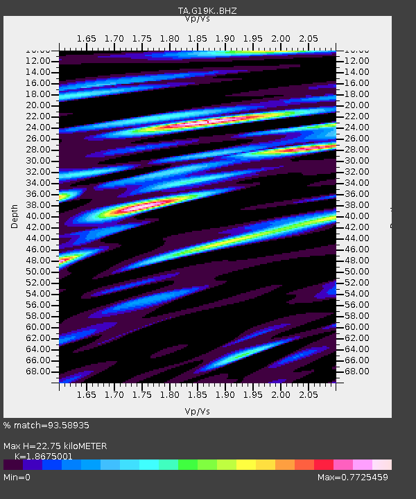
| Estimated Moho Depth: |
22.75 km |
| Estimated Crust Vp/Vs: |
1.87 |
| Assumed Crust Vp: |
6.577 km/s |
| Estimated Crust Vs: |
3.522 km/s |
| Estimated Crust Poisson's Ratio: |
0.30 |
|
| Radial Match: |
93.58935 % |
| Radial Bump: |
400 |
| Transverse Match: |
82.43632 % |
| Transverse Bump: |
400 |
| SOD ConfigId: |
19053131 |
| Insert Time: |
2019-09-01 18:11:39.241 +0000 |
| GWidth: |
2.5 |
| Max Bumps: |
400 |
| Tol: |
0.001 |
|

Signal To Noise
| Channel | StoN | STA | LTA |
| TA:G19K: :BHZ:20190818T18:10:12.924988Z | 15.970836 | 1.1081061E-6 | 6.938309E-8 |
| TA:G19K: :BHN:20190818T18:10:12.924988Z | 7.5593286 | 3.9581118E-7 | 5.2360626E-8 |
| TA:G19K: :BHE:20190818T18:10:12.924988Z | 12.447751 | 5.797937E-7 | 4.6578187E-8 |
| Arrivals |
| Ps | 3.1 SECOND |
| PpPs | 9.5 SECOND |
| PsPs/PpSs | 13 SECOND |


