You are here: Home > Network List > TA - USArray Transportable Network (new EarthScope stations) Stations List
> Station M12A Wells, NV, USA > Earthquake Result Viewer
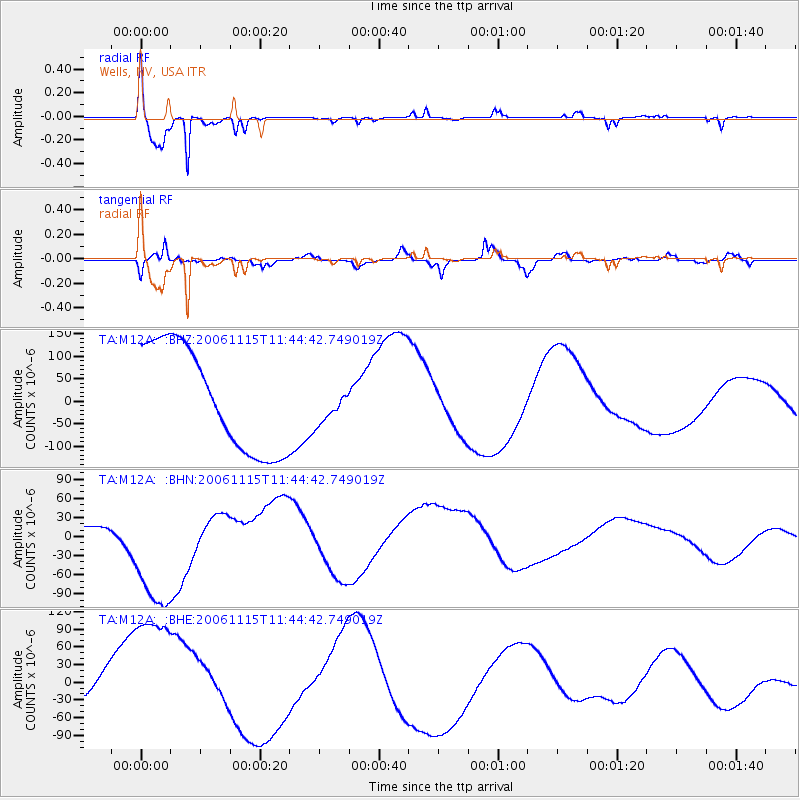
M12A Wells, NV, USA - Earthquake Result Viewer

| Earthquake location: |
East Of Kuril Islands |
| Earthquake latitude/longitude: |
46.7/155.3 |
| Earthquake time(UTC): |
2006/11/15 (319) 11:34:58 GMT |
| Earthquake Depth: |
10 km |
| Earthquake Magnitude: |
6.4 MB |
| Earthquake Catalog/Contributor: |
WHDF/NEIC |
|
| Network: |
TA USArray Transportable Network (new EarthScope stations) |
| Station: |
M12A Wells, NV, USA |
| Lat/Lon: |
41.42 N/114.92 W |
| Elevation: |
1930 m |
|
| Distance: |
61.3 deg |
| Az: |
59.002 deg |
| Baz: |
308.271 deg |
| Ray Param: |
0.06094011 |
| Estimated Moho Depth: |
16.0 km |
| Estimated Crust Vp/Vs: |
1.61 |
| Assumed Crust Vp: |
6.276 km/s |
| Estimated Crust Vs: |
3.898 km/s |
| Estimated Crust Poisson's Ratio: |
0.19 |
|
| Radial Match: |
93.585365 % |
| Radial Bump: |
212 |
| Transverse Match: |
76.40108 % |
| Transverse Bump: |
400 |
| SOD ConfigId: |
2564 |
| Insert Time: |
2010-03-07 03:18:18.482 +0000 |
| GWidth: |
2.5 |
| Max Bumps: |
400 |
| Tol: |
0.001 |
|
Signal To Noise
| Channel | StoN | STA | LTA |
| TA:M12A: :BHN:20061115T11:44:42.749019Z | 3.1814437 | 1.1001959E-4 | 3.4581655E-5 |
| TA:M12A: :BHE:20061115T11:44:42.749019Z | 3.0749462 | 1.3690747E-4 | 4.4523535E-5 |
| TA:M12A: :BHZ:20061115T11:44:42.749019Z | 0.33240196 | 3.848756E-5 | 1.157862E-4 |
| Arrivals |
| Ps | 1.6 SECOND |
| PpPs | 6.3 SECOND |
| PsPs/PpSs | 8.0 SECOND |


