You are here: Home > Network List > TA - USArray Transportable Network (new EarthScope stations) Stations List
> Station O15K Ungalikthiuk River, AK, USA > Earthquake Result Viewer
O15K Ungalikthiuk River, AK, USA - Earthquake Result Viewer
| Earthquake location: |
Mariana Islands |
| Earthquake latitude/longitude: |
16.6/146.4 |
| Earthquake time(UTC): |
2019/08/18 (230) 18:00:29 GMT |
| Earthquake Depth: |
34 km |
| Earthquake Magnitude: |
5.9 Mi |
| Earthquake Catalog/Contributor: |
NEIC PDE/pt |
|
| Network: |
TA USArray Transportable Network (new EarthScope stations) |
| Station: |
O15K Ungalikthiuk River, AK, USA |
| Lat/Lon: |
59.18 N/159.82 W |
| Elevation: |
306 m |
|
| Distance: |
57.7 deg |
| Az: |
29.441 deg |
| Baz: |
246.26 deg |
| Ray Param: |
0.063295536 |
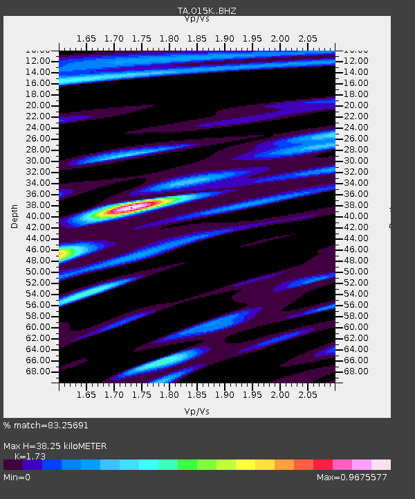
| Estimated Moho Depth: |
38.25 km |
| Estimated Crust Vp/Vs: |
1.73 |
| Assumed Crust Vp: |
6.24 km/s |
| Estimated Crust Vs: |
3.607 km/s |
| Estimated Crust Poisson's Ratio: |
0.25 |
|
| Radial Match: |
83.25691 % |
| Radial Bump: |
377 |
| Transverse Match: |
68.616585 % |
| Transverse Bump: |
400 |
| SOD ConfigId: |
19053131 |
| Insert Time: |
2019-09-01 18:12:40.042 +0000 |
| GWidth: |
2.5 |
| Max Bumps: |
400 |
| Tol: |
0.001 |
|

Signal To Noise
| Channel | StoN | STA | LTA |
| TA:O15K: :BHZ:20190818T18:09:45.250Z | 6.115392 | 9.033054E-7 | 1.4771013E-7 |
| TA:O15K: :BHN:20190818T18:09:45.250Z | 2.1549716 | 2.602014E-7 | 1.207447E-7 |
| TA:O15K: :BHE:20190818T18:09:45.250Z | 3.636022 | 4.8101475E-7 | 1.3229148E-7 |
| Arrivals |
| Ps | 4.7 SECOND |
| PpPs | 16 SECOND |
| PsPs/PpSs | 21 SECOND |


