You are here: Home > Network List > TS - TERRAscope (Southern California Seismic Network) Stations List
> Station MLAC Mammoth Lakes, California, USA > Earthquake Result Viewer
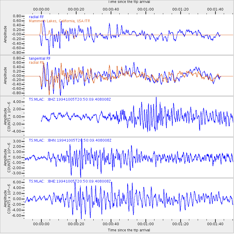
MLAC Mammoth Lakes, California, USA - Earthquake Result Viewer
*The percent match for this event was below the threshold and hence no stack was calculated.
| Earthquake location: |
Kuril Islands |
| Earthquake latitude/longitude: |
43.9/147.4 |
| Earthquake time(UTC): |
1994/10/05 (278) 20:39:47 GMT |
| Earthquake Depth: |
33 km |
| Earthquake Magnitude: |
6.2 MB, 5.6 MS, 5.9 UNKNOWN |
| Earthquake Catalog/Contributor: |
WHDF/NEIC |
|
| Network: |
TS TERRAscope (Southern California Seismic Network) |
| Station: |
MLAC Mammoth Lakes, California, USA |
| Lat/Lon: |
37.63 N/118.83 W |
| Elevation: |
2170 m |
|
| Distance: |
67.6 deg |
| Az: |
58.995 deg |
| Baz: |
308.679 deg |
| Ray Param: |
$rayparam |
*The percent match for this event was below the threshold and hence was not used in the summary stack. |
|
| Radial Match: |
49.73892 % |
| Radial Bump: |
400 |
| Transverse Match: |
63.333755 % |
| Transverse Bump: |
400 |
| SOD ConfigId: |
4480 |
| Insert Time: |
2010-02-26 14:25:45.336 +0000 |
| GWidth: |
2.5 |
| Max Bumps: |
400 |
| Tol: |
0.001 |
|
Signal To Noise
| Channel | StoN | STA | LTA |
| TS:MLAC: :BHN:19941005T20:50:09.408008Z | 1.4087349 | 3.5989675E-7 | 2.5547513E-7 |
| TS:MLAC: :BHE:19941005T20:50:09.408008Z | 1.4515272 | 9.690096E-7 | 6.6757934E-7 |
| TS:MLAC: :BHZ:19941005T20:50:09.408008Z | 1.3803308 | 7.83595E-7 | 5.6768636E-7 |
| Arrivals |
| Ps | |
| PpPs | |
| PsPs/PpSs | |


