You are here: Home > Network List > TA - USArray Transportable Network (new EarthScope stations) Stations List
> Station M12A Wells, NV, USA > Earthquake Result Viewer
M12A Wells, NV, USA - Earthquake Result Viewer
| Earthquake location: |
Kamchatka Peninsula, Russia |
| Earthquake latitude/longitude: |
54.3/158.4 |
| Earthquake time(UTC): |
2006/05/22 (142) 13:08:01 GMT |
| Earthquake Depth: |
185 km |
| Earthquake Magnitude: |
6.2 MB, 6.2 MW, 6.2 MW |
| Earthquake Catalog/Contributor: |
WHDF/NEIC |
|
| Network: |
TA USArray Transportable Network (new EarthScope stations) |
| Station: |
M12A Wells, NV, USA |
| Lat/Lon: |
41.42 N/114.92 W |
| Elevation: |
1930 m |
|
| Distance: |
56.0 deg |
| Az: |
64.949 deg |
| Baz: |
315.06 deg |
| Ray Param: |
0.063825525 |
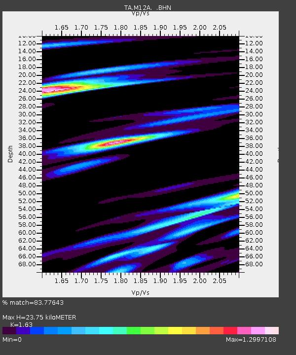
| Estimated Moho Depth: |
23.75 km |
| Estimated Crust Vp/Vs: |
1.63 |
| Assumed Crust Vp: |
6.276 km/s |
| Estimated Crust Vs: |
3.85 km/s |
| Estimated Crust Poisson's Ratio: |
0.20 |
|
| Radial Match: |
83.77643 % |
| Radial Bump: |
400 |
| Transverse Match: |
69.14019 % |
| Transverse Bump: |
400 |
| SOD ConfigId: |
2669 |
| Insert Time: |
2010-03-07 03:18:48.261 +0000 |
| GWidth: |
2.5 |
| Max Bumps: |
400 |
| Tol: |
0.001 |
|

Signal To Noise
| Channel | StoN | STA | LTA |
| TA:M12A: :BHN:20060522T13:16:50.075029Z | 2.4416947 | 9.2871056E-7 | 3.803549E-7 |
| TA:M12A: :BHE:20060522T13:16:50.075029Z | 1.4813402 | 6.6748237E-7 | 4.505936E-7 |
| TA:M12A: :BHZ:20060522T13:16:50.075029Z | 2.0494125 | 1.3042064E-6 | 6.3638066E-7 |
| Arrivals |
| Ps | 2.5 SECOND |
| PpPs | 9.4 SECOND |
| PsPs/PpSs | 12 SECOND |


