You are here: Home > Network List > WY - Yellowstone Wyoming Seismic Network Stations List
> Station YTP The Promontory, YNP, WY, USA > Earthquake Result Viewer
YTP The Promontory, YNP, WY, USA - Earthquake Result Viewer
| Earthquake location: |
South Of Fiji Islands |
| Earthquake latitude/longitude: |
-19.3/176.1 |
| Earthquake time(UTC): |
2017/01/03 (003) 21:52:31 GMT |
| Earthquake Depth: |
17 km |
| Earthquake Magnitude: |
6.9 Mww |
| Earthquake Catalog/Contributor: |
NEIC PDE/us |
|
| Network: |
WY Yellowstone Wyoming Seismic Network |
| Station: |
YTP The Promontory, YNP, WY, USA |
| Lat/Lon: |
44.39 N/110.29 W |
| Elevation: |
2384 m |
|
| Distance: |
92.2 deg |
| Az: |
43.511 deg |
| Baz: |
245.08 deg |
| Ray Param: |
0.04148739 |
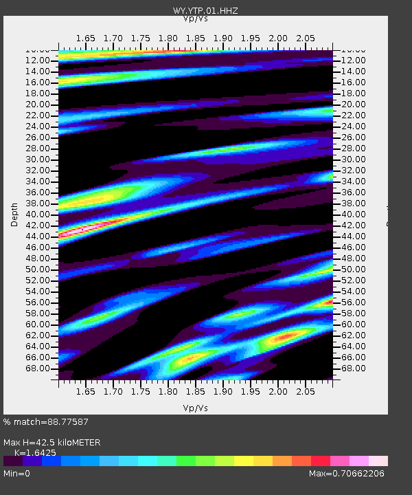
| Estimated Moho Depth: |
42.5 km |
| Estimated Crust Vp/Vs: |
1.64 |
| Assumed Crust Vp: |
6.35 km/s |
| Estimated Crust Vs: |
3.866 km/s |
| Estimated Crust Poisson's Ratio: |
0.21 |
|
| Radial Match: |
88.77587 % |
| Radial Bump: |
400 |
| Transverse Match: |
86.721344 % |
| Transverse Bump: |
400 |
| SOD ConfigId: |
1943534 |
| Insert Time: |
2017-01-17 21:57:28.074 +0000 |
| GWidth: |
2.5 |
| Max Bumps: |
400 |
| Tol: |
0.001 |
|

Signal To Noise
| Channel | StoN | STA | LTA |
| WY:YTP:01:HHZ:20170103T22:05:08.597988Z | 9.103159 | 3.5309366E-8 | 3.878804E-9 |
| WY:YTP:01:HHN:20170103T22:05:08.597988Z | 1.2742393 | 7.921866E-9 | 6.216937E-9 |
| WY:YTP:01:HHE:20170103T22:05:08.597988Z | 2.060784 | 1.2372306E-8 | 6.003689E-9 |
| Arrivals |
| Ps | 4.4 SECOND |
| PpPs | 17 SECOND |
| PsPs/PpSs | 22 SECOND |


