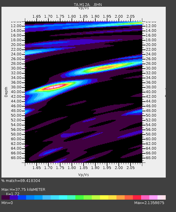
M12A Wells, NV, USA - Earthquake Result Viewer
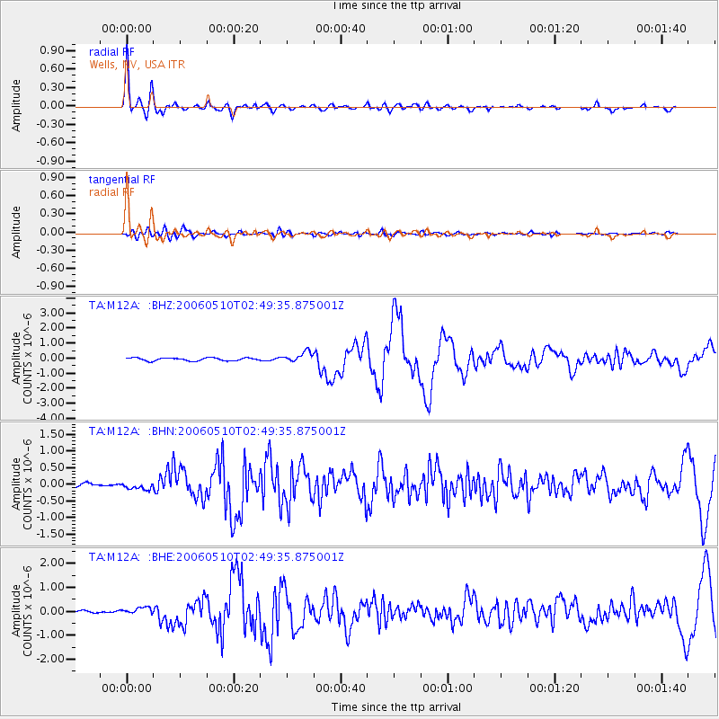
Earthquake location: Fox Islands, Aleutian Islands
Earthquake latitude/longitude: 52.5/-169.3
Earthquake time(UTC): 2006/05/10 (130) 02:42:51 GMT
Earthquake Depth: 18 km
Earthquake Magnitude: 6.1 MB, 6.2 MS, 6.4 MW, 6.3 MW
Earthquake Catalog/Contributor: WHDF/NEIC
Network: TA USArray Transportable Network (new EarthScope stations)
Station: M12A Wells, NV, USA
Lat/Lon: 41.42 N/114.92 W
Elevation: 1930 m
Distance: 37.9 deg
Az: 84.793 deg
Baz: 305.984 deg
Ray Param: 0.07587996
Estimated Moho Depth: 37.75 km
Estimated Crust Vp/Vs: 1.72
Assumed Crust Vp: 6.276 km/s
Estimated Crust Vs: 3.649 km/s
Estimated Crust Poisson's Ratio: 0.24
Radial Match: 89.418304 %
Radial Bump: 400
Transverse Match: 68.2 %
Transverse Bump: 400
SOD ConfigId: 2669
Insert Time: 2010-03-07 03:18:57.762 +0000
GWidth: 2.5
Max Bumps: 400
Tol: 0.001

Signal To Noise

ChannelStoNSTALTA
TA:M12A: :BHN:20060510T02:49:35.875001Z1.07246359.078341E-88.4649415E-8
TA:M12A: :BHE:20060510T02:49:35.875001Z2.43601561.425938E-75.8535665E-8
TA:M12A: :BHZ:20060510T02:49:35.875001Z3.54305053.4770557E-79.813735E-8
Arrivals
Ps4.7 SECOND
PpPs15 SECOND
PsPs/PpSs20 SECOND