You are here: Home > Network List > US - United States National Seismic Network Stations List
> Station DGMT Dagmar, Montana, USA > Earthquake Result Viewer
DGMT Dagmar, Montana, USA - Earthquake Result Viewer
*The percent match for this event was below the threshold and hence no stack was calculated.
| Earthquake location: |
Mariana Islands |
| Earthquake latitude/longitude: |
16.6/146.4 |
| Earthquake time(UTC): |
2019/08/18 (230) 18:00:29 GMT |
| Earthquake Depth: |
34 km |
| Earthquake Magnitude: |
5.9 Mi |
| Earthquake Catalog/Contributor: |
NEIC PDE/pt |
|
| Network: |
US United States National Seismic Network |
| Station: |
DGMT Dagmar, Montana, USA |
| Lat/Lon: |
48.47 N/104.20 W |
| Elevation: |
0.0 m |
|
| Distance: |
90.0 deg |
| Az: |
38.888 deg |
| Baz: |
295.225 deg |
| Ray Param: |
$rayparam |
*The percent match for this event was below the threshold and hence was not used in the summary stack. |
|
| Radial Match: |
56.39691 % |
| Radial Bump: |
400 |
| Transverse Match: |
55.910297 % |
| Transverse Bump: |
400 |
| SOD ConfigId: |
19053131 |
| Insert Time: |
2019-09-01 18:13:44.949 +0000 |
| GWidth: |
2.5 |
| Max Bumps: |
400 |
| Tol: |
0.001 |
|
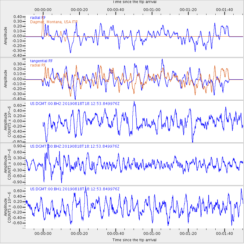
Signal To Noise
| Channel | StoN | STA | LTA |
| US:DGMT:00:BHZ:20190818T18:12:53.849976Z | 3.2468622 | 4.7778906E-7 | 1.471541E-7 |
| US:DGMT:00:BH1:20190818T18:12:53.849976Z | 1.5189354 | 2.6725624E-7 | 1.7594972E-7 |
| US:DGMT:00:BH2:20190818T18:12:53.849976Z | 1.0307511 | 2.899E-7 | 2.812512E-7 |
| Arrivals |
| Ps | |
| PpPs | |
| PsPs/PpSs | |


