You are here: Home > Network List > UU - University of Utah Regional Network Stations List
> Station FOR4 Blundell West, UT, USA > Earthquake Result Viewer
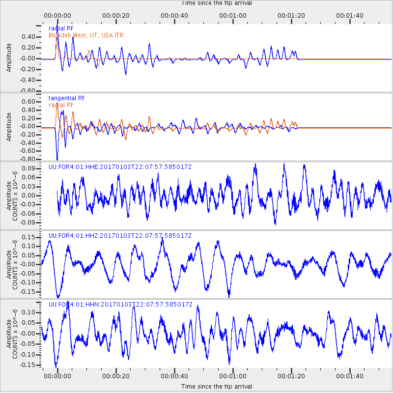
FOR4 Blundell West, UT, USA - Earthquake Result Viewer
*The percent match for this event was below the threshold and hence no stack was calculated.
| Earthquake location: |
South Of Fiji Islands |
| Earthquake latitude/longitude: |
-19.4/175.8 |
| Earthquake time(UTC): |
2017/01/03 (003) 21:55:38 GMT |
| Earthquake Depth: |
10 km |
| Earthquake Magnitude: |
5.7 mb |
| Earthquake Catalog/Contributor: |
NEIC PDE/us |
|
| Network: |
UU University of Utah Regional Network |
| Station: |
FOR4 Blundell West, UT, USA |
| Lat/Lon: |
38.50 N/112.90 W |
| Elevation: |
1657 m |
|
| Distance: |
88.1 deg |
| Az: |
48.027 deg |
| Baz: |
243.401 deg |
| Ray Param: |
$rayparam |
*The percent match for this event was below the threshold and hence was not used in the summary stack. |
|
| Radial Match: |
64.08777 % |
| Radial Bump: |
400 |
| Transverse Match: |
71.387474 % |
| Transverse Bump: |
400 |
| SOD ConfigId: |
1943534 |
| Insert Time: |
2017-01-17 21:59:51.509 +0000 |
| GWidth: |
2.5 |
| Max Bumps: |
400 |
| Tol: |
0.001 |
|
Signal To Noise
| Channel | StoN | STA | LTA |
| UU:FOR4:01:HHZ:20170103T22:07:57.585017Z | 2.6699522 | 1.0381114E-7 | 3.8881275E-8 |
| UU:FOR4:01:HHN:20170103T22:07:57.585017Z | 2.8770792 | 9.6435365E-8 | 3.3518496E-8 |
| UU:FOR4:01:HHE:20170103T22:07:57.585017Z | 1.3594897 | 4.1385363E-8 | 3.0441836E-8 |
| Arrivals |
| Ps | |
| PpPs | |
| PsPs/PpSs | |


