You are here: Home > Network List > TS - TERRAscope (Southern California Seismic Network) Stations List
> Station MLAC Mammoth Lakes, California, USA > Earthquake Result Viewer
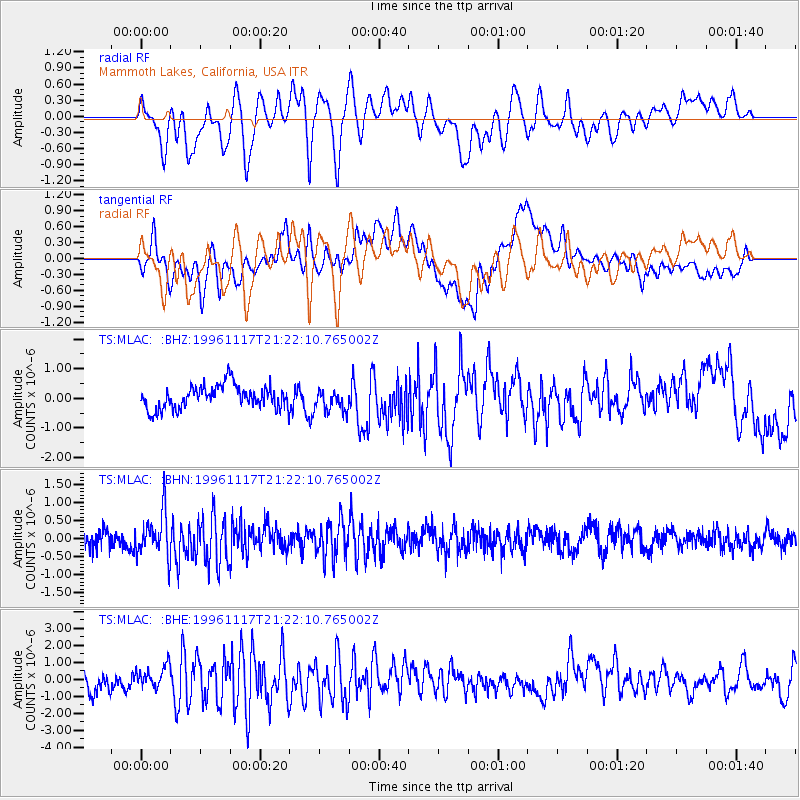
MLAC Mammoth Lakes, California, USA - Earthquake Result Viewer
*The percent match for this event was below the threshold and hence no stack was calculated.
| Earthquake location: |
South Of Fiji Islands |
| Earthquake latitude/longitude: |
-22.2/-179.7 |
| Earthquake time(UTC): |
1996/11/17 (322) 21:11:20 GMT |
| Earthquake Depth: |
592 km |
| Earthquake Magnitude: |
5.5 MB, 6.1 UNKNOWN, 6.0 MW |
| Earthquake Catalog/Contributor: |
WHDF/NEIC |
|
| Network: |
TS TERRAscope (Southern California Seismic Network) |
| Station: |
MLAC Mammoth Lakes, California, USA |
| Lat/Lon: |
37.63 N/118.83 W |
| Elevation: |
2170 m |
|
| Distance: |
82.5 deg |
| Az: |
44.382 deg |
| Baz: |
234.733 deg |
| Ray Param: |
$rayparam |
*The percent match for this event was below the threshold and hence was not used in the summary stack. |
|
| Radial Match: |
56.7943 % |
| Radial Bump: |
400 |
| Transverse Match: |
62.149307 % |
| Transverse Bump: |
400 |
| SOD ConfigId: |
4480 |
| Insert Time: |
2010-02-26 14:25:46.595 +0000 |
| GWidth: |
2.5 |
| Max Bumps: |
400 |
| Tol: |
0.001 |
|
Signal To Noise
| Channel | StoN | STA | LTA |
| TS:MLAC: :BHN:19961117T21:22:10.765002Z | 2.8918967 | 6.127326E-7 | 2.1187914E-7 |
| TS:MLAC: :BHE:19961117T21:22:10.765002Z | 0.8065566 | 5.7635685E-7 | 7.145894E-7 |
| TS:MLAC: :BHZ:19961117T21:22:10.765002Z | 0.96062624 | 3.7623695E-7 | 3.91658E-7 |
| Arrivals |
| Ps | |
| PpPs | |
| PsPs/PpSs | |


