You are here: Home > Network List > WY - Yellowstone Wyoming Seismic Network Stations List
> Station YHH Holmes Hill, YNP, WY, USA > Earthquake Result Viewer
YHH Holmes Hill, YNP, WY, USA - Earthquake Result Viewer
| Earthquake location: |
Mariana Islands |
| Earthquake latitude/longitude: |
16.6/146.4 |
| Earthquake time(UTC): |
2019/08/18 (230) 18:00:29 GMT |
| Earthquake Depth: |
34 km |
| Earthquake Magnitude: |
5.9 Mi |
| Earthquake Catalog/Contributor: |
NEIC PDE/pt |
|
| Network: |
WY Yellowstone Wyoming Seismic Network |
| Station: |
YHH Holmes Hill, YNP, WY, USA |
| Lat/Lon: |
44.79 N/110.85 W |
| Elevation: |
2717 m |
|
| Distance: |
87.2 deg |
| Az: |
44.06 deg |
| Baz: |
290.523 deg |
| Ray Param: |
0.043443516 |
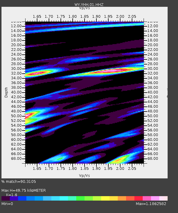
| Estimated Moho Depth: |
49.75 km |
| Estimated Crust Vp/Vs: |
1.60 |
| Assumed Crust Vp: |
6.35 km/s |
| Estimated Crust Vs: |
3.969 km/s |
| Estimated Crust Poisson's Ratio: |
0.18 |
|
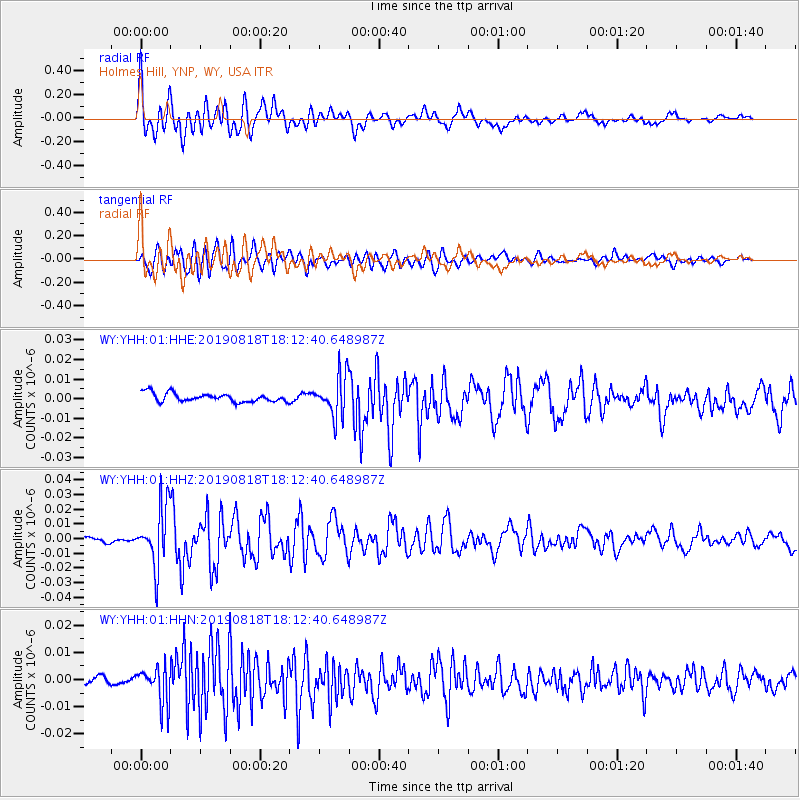
| Radial Match: |
90.3105 % |
| Radial Bump: |
400 |
| Transverse Match: |
79.947525 % |
| Transverse Bump: |
400 |
| SOD ConfigId: |
19053131 |
| Insert Time: |
2019-09-01 18:15:05.827 +0000 |
| GWidth: |
2.5 |
| Max Bumps: |
400 |
| Tol: |
0.001 |
|
Signal To Noise
| Channel | StoN | STA | LTA |
| WY:YHH:01:HHZ:20190818T18:12:40.648987Z | 9.734832 | 2.0325272E-8 | 2.0878914E-9 |
| WY:YHH:01:HHN:20190818T18:12:40.648987Z | 4.142084 | 6.8251387E-9 | 1.6477548E-9 |
| WY:YHH:01:HHE:20190818T18:12:40.648987Z | 4.806809 | 1.0596417E-8 | 2.20446E-9 |
| Arrivals |
| Ps | 4.8 SECOND |
| PpPs | 20 SECOND |
| PsPs/PpSs | 25 SECOND |


