You are here: Home > Network List > WY - Yellowstone Wyoming Seismic Network Stations List
> Station YNR Norris Junction, YNP, WY, USA > Earthquake Result Viewer
YNR Norris Junction, YNP, WY, USA - Earthquake Result Viewer

| Earthquake location: |
Mariana Islands |
| Earthquake latitude/longitude: |
16.6/146.4 |
| Earthquake time(UTC): |
2019/08/18 (230) 18:00:29 GMT |
| Earthquake Depth: |
34 km |
| Earthquake Magnitude: |
5.9 Mi |
| Earthquake Catalog/Contributor: |
NEIC PDE/pt |
|
| Network: |
WY Yellowstone Wyoming Seismic Network |
| Station: |
YNR Norris Junction, YNP, WY, USA |
| Lat/Lon: |
44.72 N/110.68 W |
| Elevation: |
2336 m |
|
| Distance: |
87.4 deg |
| Az: |
44.086 deg |
| Baz: |
290.644 deg |
| Ray Param: |
0.04334538 |
| Estimated Moho Depth: |
66.0 km |
| Estimated Crust Vp/Vs: |
1.61 |
| Assumed Crust Vp: |
6.35 km/s |
| Estimated Crust Vs: |
3.956 km/s |
| Estimated Crust Poisson's Ratio: |
0.18 |
|
| Radial Match: |
81.42289 % |
| Radial Bump: |
400 |
| Transverse Match: |
55.61249 % |
| Transverse Bump: |
400 |
| SOD ConfigId: |
19053131 |
| Insert Time: |
2019-09-01 18:15:13.328 +0000 |
| GWidth: |
2.5 |
| Max Bumps: |
400 |
| Tol: |
0.001 |
|
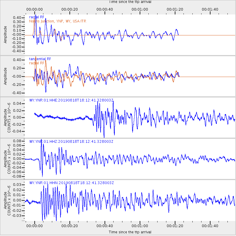
Signal To Noise
| Channel | StoN | STA | LTA |
| WY:YNR:01:HHZ:20190818T18:12:41.328003Z | 19.680744 | 3.0406493E-8 | 1.544987E-9 |
| WY:YNR:01:HHN:20190818T18:12:41.328003Z | 2.2245429 | 1.2642297E-8 | 5.683099E-9 |
| WY:YNR:01:HHE:20190818T18:12:41.328003Z | 1.6459147 | 7.534916E-9 | 4.5779505E-9 |
| Arrivals |
| Ps | 6.4 SECOND |
| PpPs | 26 SECOND |
| PsPs/PpSs | 33 SECOND |


