You are here: Home > Network List > XV14 - Fault Locations and Alaska Tectonics from Seismicity Stations List
> Station F6TP Tanana River 6, Topo, AK, USA > Earthquake Result Viewer
F6TP Tanana River 6, Topo, AK, USA - Earthquake Result Viewer
| Earthquake location: |
Mariana Islands |
| Earthquake latitude/longitude: |
16.6/146.4 |
| Earthquake time(UTC): |
2019/08/18 (230) 18:00:29 GMT |
| Earthquake Depth: |
34 km |
| Earthquake Magnitude: |
5.9 Mi |
| Earthquake Catalog/Contributor: |
NEIC PDE/pt |
|
| Network: |
XV Fault Locations and Alaska Tectonics from Seismicity |
| Station: |
F6TP Tanana River 6, Topo, AK, USA |
| Lat/Lon: |
64.87 N/149.56 W |
| Elevation: |
120 m |
|
| Distance: |
64.2 deg |
| Az: |
25.244 deg |
| Baz: |
253.284 deg |
| Ray Param: |
0.059043672 |
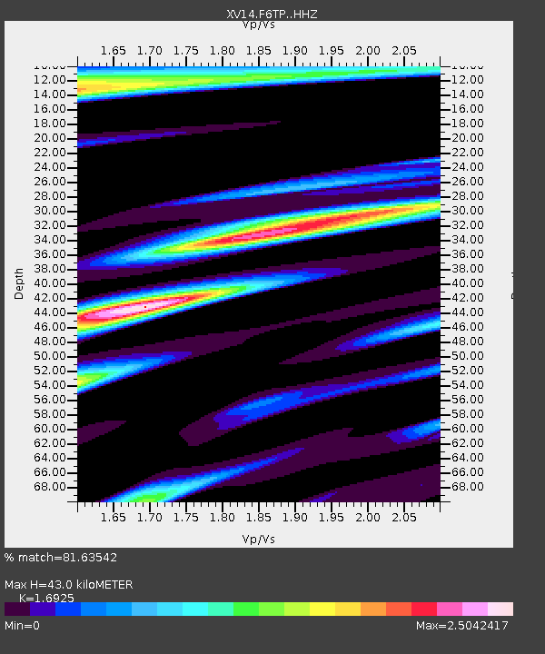
| Estimated Moho Depth: |
43.0 km |
| Estimated Crust Vp/Vs: |
1.69 |
| Assumed Crust Vp: |
6.566 km/s |
| Estimated Crust Vs: |
3.88 km/s |
| Estimated Crust Poisson's Ratio: |
0.23 |
|
| Radial Match: |
81.63542 % |
| Radial Bump: |
400 |
| Transverse Match: |
73.451164 % |
| Transverse Bump: |
400 |
| SOD ConfigId: |
19053131 |
| Insert Time: |
2019-09-01 18:15:21.364 +0000 |
| GWidth: |
2.5 |
| Max Bumps: |
400 |
| Tol: |
0.001 |
|

Signal To Noise
| Channel | StoN | STA | LTA |
| XV:F6TP: :HHZ:20190818T18:10:29.390015Z | 24.038557 | 3.0711487E-6 | 1.2775928E-7 |
| XV:F6TP: :HHN:20190818T18:10:29.390015Z | 1.8959619 | 6.3630847E-7 | 3.3561247E-7 |
| XV:F6TP: :HHE:20190818T18:10:29.390015Z | 3.6029212 | 1.4830468E-6 | 4.1162346E-7 |
| Arrivals |
| Ps | 4.8 SECOND |
| PpPs | 17 SECOND |
| PsPs/PpSs | 22 SECOND |


