You are here: Home > Network List > TS - TERRAscope (Southern California Seismic Network) Stations List
> Station MLAC Mammoth Lakes, California, USA > Earthquake Result Viewer
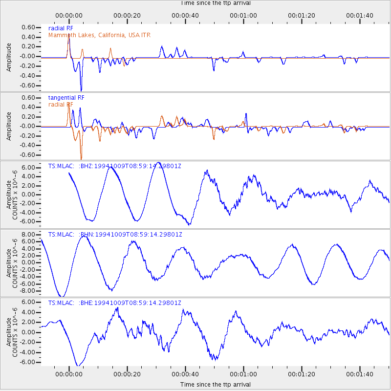
MLAC Mammoth Lakes, California, USA - Earthquake Result Viewer
*The percent match for this event was below the threshold and hence no stack was calculated.
| Earthquake location: |
East Of Kuril Islands |
| Earthquake latitude/longitude: |
43.8/148.1 |
| Earthquake time(UTC): |
1994/10/09 (282) 08:48:54 GMT |
| Earthquake Depth: |
35 km |
| Earthquake Magnitude: |
5.8 MB |
| Earthquake Catalog/Contributor: |
WHDF/NEIC |
|
| Network: |
TS TERRAscope (Southern California Seismic Network) |
| Station: |
MLAC Mammoth Lakes, California, USA |
| Lat/Lon: |
37.63 N/118.83 W |
| Elevation: |
2170 m |
|
| Distance: |
67.1 deg |
| Az: |
59.354 deg |
| Baz: |
308.335 deg |
| Ray Param: |
$rayparam |
*The percent match for this event was below the threshold and hence was not used in the summary stack. |
|
| Radial Match: |
88.44447 % |
| Radial Bump: |
400 |
| Transverse Match: |
74.91689 % |
| Transverse Bump: |
400 |
| SOD ConfigId: |
4480 |
| Insert Time: |
2010-02-26 14:25:50.632 +0000 |
| GWidth: |
2.5 |
| Max Bumps: |
400 |
| Tol: |
0.001 |
|
Signal To Noise
| Channel | StoN | STA | LTA |
| TS:MLAC: :BHN:19941009T08:59:14.29801Z | 0.9774356 | 5.156012E-6 | 5.27504E-6 |
| TS:MLAC: :BHE:19941009T08:59:14.29801Z | 3.7142453 | 5.2889877E-6 | 1.4239737E-6 |
| TS:MLAC: :BHZ:19941009T08:59:14.29801Z | 1.4260113 | 5.84263E-6 | 4.097183E-6 |
| Arrivals |
| Ps | |
| PpPs | |
| PsPs/PpSs | |


