You are here: Home > Network List > US - United States National Seismic Network Stations List
> Station HAWA Hanford, Washington, USA > Earthquake Result Viewer
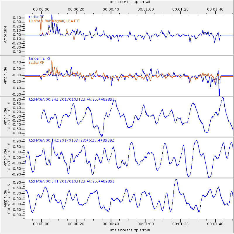
HAWA Hanford, Washington, USA - Earthquake Result Viewer
*The percent match for this event was below the threshold and hence no stack was calculated.
| Earthquake location: |
Fiji Islands Region |
| Earthquake latitude/longitude: |
-18.9/176.3 |
| Earthquake time(UTC): |
2017/01/03 (003) 23:34:11 GMT |
| Earthquake Depth: |
10 km |
| Earthquake Magnitude: |
5.6 mb |
| Earthquake Catalog/Contributor: |
NEIC PDE/us |
|
| Network: |
US United States National Seismic Network |
| Station: |
HAWA Hanford, Washington, USA |
| Lat/Lon: |
46.39 N/119.53 W |
| Elevation: |
364 m |
|
| Distance: |
87.0 deg |
| Az: |
38.612 deg |
| Baz: |
238.59 deg |
| Ray Param: |
$rayparam |
*The percent match for this event was below the threshold and hence was not used in the summary stack. |
|
| Radial Match: |
75.34479 % |
| Radial Bump: |
400 |
| Transverse Match: |
53.959087 % |
| Transverse Bump: |
400 |
| SOD ConfigId: |
1943534 |
| Insert Time: |
2017-01-17 23:36:02.738 +0000 |
| GWidth: |
2.5 |
| Max Bumps: |
400 |
| Tol: |
0.001 |
|
Signal To Noise
| Channel | StoN | STA | LTA |
| US:HAWA:00:BHZ:20170103T23:46:25.448989Z | 0.66380036 | 2.934451E-7 | 4.420683E-7 |
| US:HAWA:00:BH1:20170103T23:46:25.448989Z | 1.4049023 | 4.6466684E-7 | 3.3074673E-7 |
| US:HAWA:00:BH2:20170103T23:46:25.448989Z | 2.245035 | 5.751283E-7 | 2.561779E-7 |
| Arrivals |
| Ps | |
| PpPs | |
| PsPs/PpSs | |


