You are here: Home > Network List > CI - Caltech Regional Seismic Network Stations List
> Station MPM Manuel Prospect Mine, California, USA > Earthquake Result Viewer
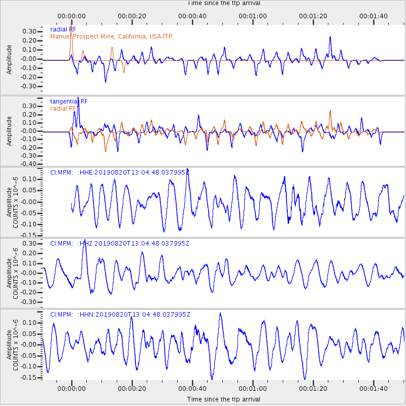
MPM Manuel Prospect Mine, California, USA - Earthquake Result Viewer
*The percent match for this event was below the threshold and hence no stack was calculated.
| Earthquake location: |
Ryukyu Islands, Japan |
| Earthquake latitude/longitude: |
28.0/130.9 |
| Earthquake time(UTC): |
2019/08/20 (232) 12:52:22 GMT |
| Earthquake Depth: |
10 km |
| Earthquake Magnitude: |
5.2 Mww |
| Earthquake Catalog/Contributor: |
NEIC PDE/us |
|
| Network: |
CI Caltech Regional Seismic Network |
| Station: |
MPM Manuel Prospect Mine, California, USA |
| Lat/Lon: |
36.06 N/117.49 W |
| Elevation: |
185 m |
|
| Distance: |
89.5 deg |
| Az: |
48.874 deg |
| Baz: |
304.683 deg |
| Ray Param: |
$rayparam |
*The percent match for this event was below the threshold and hence was not used in the summary stack. |
|
| Radial Match: |
49.717625 % |
| Radial Bump: |
348 |
| Transverse Match: |
59.24811 % |
| Transverse Bump: |
381 |
| SOD ConfigId: |
19053131 |
| Insert Time: |
2019-09-03 12:56:18.383 +0000 |
| GWidth: |
2.5 |
| Max Bumps: |
400 |
| Tol: |
0.001 |
|
Signal To Noise
| Channel | StoN | STA | LTA |
| CI:MPM: :HHZ:20190820T13:04:48.037995Z | 2.4018362 | 1.5853686E-7 | 6.600653E-8 |
| CI:MPM: :HHN:20190820T13:04:48.037995Z | 0.59253025 | 3.0556066E-8 | 5.1568787E-8 |
| CI:MPM: :HHE:20190820T13:04:48.037995Z | 1.4018946 | 7.565156E-8 | 5.39638E-8 |
| Arrivals |
| Ps | |
| PpPs | |
| PsPs/PpSs | |


