You are here: Home > Network List > TS - TERRAscope (Southern California Seismic Network) Stations List
> Station MLAC Mammoth Lakes, California, USA > Earthquake Result Viewer
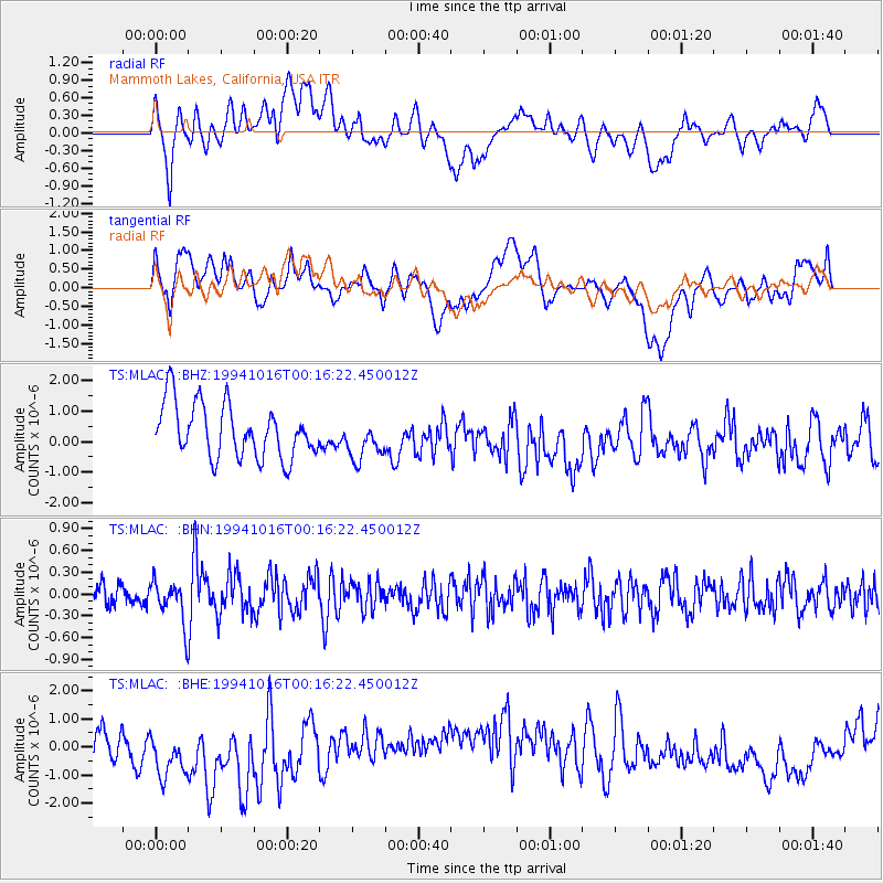
MLAC Mammoth Lakes, California, USA - Earthquake Result Viewer
*The percent match for this event was below the threshold and hence no stack was calculated.
| Earthquake location: |
Central Peru |
| Earthquake latitude/longitude: |
-9.3/-75.8 |
| Earthquake time(UTC): |
1994/10/16 (289) 00:06:49 GMT |
| Earthquake Depth: |
131 km |
| Earthquake Magnitude: |
5.6 UNKNOWN, 5.4 MB, 5.6 MW |
| Earthquake Catalog/Contributor: |
WHDF/NEIC |
|
| Network: |
TS TERRAscope (Southern California Seismic Network) |
| Station: |
MLAC Mammoth Lakes, California, USA |
| Lat/Lon: |
37.63 N/118.83 W |
| Elevation: |
2170 m |
|
| Distance: |
61.6 deg |
| Az: |
321.984 deg |
| Baz: |
130.03 deg |
| Ray Param: |
$rayparam |
*The percent match for this event was below the threshold and hence was not used in the summary stack. |
|
| Radial Match: |
41.61855 % |
| Radial Bump: |
400 |
| Transverse Match: |
28.976173 % |
| Transverse Bump: |
400 |
| SOD ConfigId: |
4480 |
| Insert Time: |
2010-02-26 14:25:53.495 +0000 |
| GWidth: |
2.5 |
| Max Bumps: |
400 |
| Tol: |
0.001 |
|
Signal To Noise
| Channel | StoN | STA | LTA |
| TS:MLAC: :BHN:19941016T00:16:22.450012Z | 1.4029276 | 2.846667E-7 | 2.0290904E-7 |
| TS:MLAC: :BHE:19941016T00:16:22.450012Z | 1.3884434 | 1.6366159E-6 | 1.1787416E-6 |
| TS:MLAC: :BHZ:19941016T00:16:22.450012Z | 0.77980524 | 6.8257464E-7 | 8.753143E-7 |
| Arrivals |
| Ps | |
| PpPs | |
| PsPs/PpSs | |


