You are here: Home > Network List > TS - TERRAscope (Southern California Seismic Network) Stations List
> Station MLAC Mammoth Lakes, California, USA > Earthquake Result Viewer
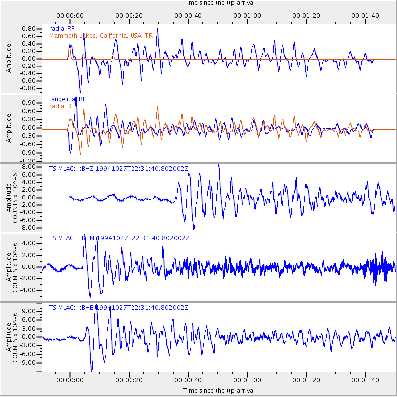
MLAC Mammoth Lakes, California, USA - Earthquake Result Viewer
*The percent match for this event was below the threshold and hence no stack was calculated.
| Earthquake location: |
South Of Fiji Islands |
| Earthquake latitude/longitude: |
-25.8/179.3 |
| Earthquake time(UTC): |
1994/10/27 (300) 22:20:31 GMT |
| Earthquake Depth: |
549 km |
| Earthquake Magnitude: |
5.9 MB, 6.8 UNKNOWN, 6.7 MW |
| Earthquake Catalog/Contributor: |
WHDF/NEIC |
|
| Network: |
TS TERRAscope (Southern California Seismic Network) |
| Station: |
MLAC Mammoth Lakes, California, USA |
| Lat/Lon: |
37.63 N/118.83 W |
| Elevation: |
2170 m |
|
| Distance: |
85.7 deg |
| Az: |
44.572 deg |
| Baz: |
232.835 deg |
| Ray Param: |
$rayparam |
*The percent match for this event was below the threshold and hence was not used in the summary stack. |
|
| Radial Match: |
82.56063 % |
| Radial Bump: |
400 |
| Transverse Match: |
77.86388 % |
| Transverse Bump: |
400 |
| SOD ConfigId: |
4480 |
| Insert Time: |
2010-02-26 14:25:55.485 +0000 |
| GWidth: |
2.5 |
| Max Bumps: |
400 |
| Tol: |
0.001 |
|
Signal To Noise
| Channel | StoN | STA | LTA |
| TS:MLAC: :BHN:19941027T22:31:40.802002Z | 4.369112 | 1.2449788E-6 | 2.8495006E-7 |
| TS:MLAC: :BHE:19941027T22:31:40.802002Z | 0.7454172 | 7.9924206E-7 | 1.0722077E-6 |
| TS:MLAC: :BHZ:19941027T22:31:40.802002Z | 1.3337084 | 6.371491E-7 | 4.7772744E-7 |
| Arrivals |
| Ps | |
| PpPs | |
| PsPs/PpSs | |


