You are here: Home > Network List > IU - Global Seismograph Network (GSN - IRIS/USGS) Stations List
> Station PMG Port Moresby, New Guinea > Earthquake Result Viewer
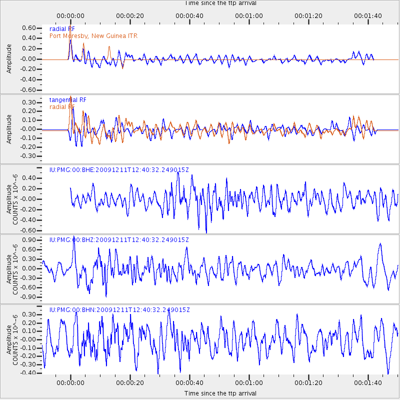
PMG Port Moresby, New Guinea - Earthquake Result Viewer
*The percent match for this event was below the threshold and hence no stack was calculated.
| Earthquake location: |
Tonga Islands |
| Earthquake latitude/longitude: |
-21.1/-174.4 |
| Earthquake time(UTC): |
2009/12/11 (345) 12:33:39 GMT |
| Earthquake Depth: |
10 km |
| Earthquake Magnitude: |
5.5 MB, 5.3 MS, 5.6 MW, 5.6 MW |
| Earthquake Catalog/Contributor: |
WHDF/NEIC |
|
| Network: |
IU Global Seismograph Network (GSN - IRIS/USGS) |
| Station: |
PMG Port Moresby, New Guinea |
| Lat/Lon: |
9.40 S/147.16 E |
| Elevation: |
90 m |
|
| Distance: |
38.7 deg |
| Az: |
281.494 deg |
| Baz: |
111.935 deg |
| Ray Param: |
$rayparam |
*The percent match for this event was below the threshold and hence was not used in the summary stack. |
|
| Radial Match: |
63.32706 % |
| Radial Bump: |
400 |
| Transverse Match: |
56.712902 % |
| Transverse Bump: |
400 |
| SOD ConfigId: |
1 |
| Insert Time: |
2010-02-19 01:22:49.490 +0000 |
| GWidth: |
2.5 |
| Max Bumps: |
400 |
| Tol: |
0.001 |
|
Signal To Noise
| Channel | StoN | STA | LTA |
| IU:PMG:00:BHZ:20091211T12:40:32.249015Z | 3.5360055 | 3.7744303E-7 | 1.06742775E-7 |
| IU:PMG:00:BHN:20091211T12:40:32.249015Z | 1.7056284 | 1.7777164E-7 | 1.0422647E-7 |
| IU:PMG:00:BHE:20091211T12:40:32.249015Z | 1.4908067 | 1.7923254E-7 | 1.202252E-7 |
| Arrivals |
| Ps | |
| PpPs | |
| PsPs/PpSs | |


