You are here: Home > Network List > TA - USArray Transportable Network (new EarthScope stations) Stations List
> Station Q07A Schurz, NV, USA > Earthquake Result Viewer
Q07A Schurz, NV, USA - Earthquake Result Viewer
| Earthquake location: |
Near West Coast Of Colombia |
| Earthquake latitude/longitude: |
3.0/-78.0 |
| Earthquake time(UTC): |
2007/09/10 (253) 01:49:14 GMT |
| Earthquake Depth: |
31 km |
| Earthquake Magnitude: |
6.1 MB, 6.7 MS, 6.8 MW |
| Earthquake Catalog/Contributor: |
WHDF/NEIC |
|
| Network: |
TA USArray Transportable Network (new EarthScope stations) |
| Station: |
Q07A Schurz, NV, USA |
| Lat/Lon: |
38.94 N/118.81 W |
| Elevation: |
1276 m |
|
| Distance: |
51.6 deg |
| Az: |
319.379 deg |
| Baz: |
123.52 deg |
| Ray Param: |
0.067271166 |
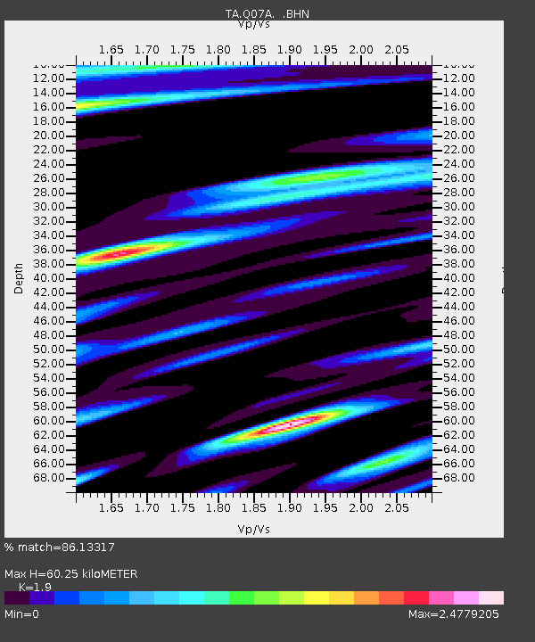
| Estimated Moho Depth: |
60.25 km |
| Estimated Crust Vp/Vs: |
1.90 |
| Assumed Crust Vp: |
6.279 km/s |
| Estimated Crust Vs: |
3.305 km/s |
| Estimated Crust Poisson's Ratio: |
0.31 |
|
| Radial Match: |
86.13317 % |
| Radial Bump: |
400 |
| Transverse Match: |
78.13061 % |
| Transverse Bump: |
400 |
| SOD ConfigId: |
2564 |
| Insert Time: |
2010-03-07 03:21:27.847 +0000 |
| GWidth: |
2.5 |
| Max Bumps: |
400 |
| Tol: |
0.001 |
|
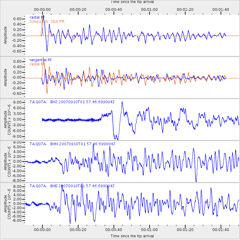
Signal To Noise
| Channel | StoN | STA | LTA |
| TA:Q07A: :BHN:20070910T01:57:46.699004Z | 1.4140642 | 3.3126085E-7 | 2.3426155E-7 |
| TA:Q07A: :BHE:20070910T01:57:46.699004Z | 2.4082365 | 9.3416065E-7 | 3.879024E-7 |
| TA:Q07A: :BHZ:20070910T01:57:46.699004Z | 4.193123 | 1.3241817E-6 | 3.1579845E-7 |
| Arrivals |
| Ps | 9.1 SECOND |
| PpPs | 26 SECOND |
| PsPs/PpSs | 36 SECOND |


