You are here: Home > Network List > TA - USArray Transportable Network (new EarthScope stations) Stations List
> Station Q07A Schurz, NV, USA > Earthquake Result Viewer
Q07A Schurz, NV, USA - Earthquake Result Viewer
| Earthquake location: |
Tonga Islands |
| Earthquake latitude/longitude: |
-20.2/-174.1 |
| Earthquake time(UTC): |
2006/05/03 (123) 15:26:40 GMT |
| Earthquake Depth: |
55 km |
| Earthquake Magnitude: |
7.2 MB, 7.8 MS, 7.9 MW, 7.9 MW |
| Earthquake Catalog/Contributor: |
WHDF/NEIC |
|
| Network: |
TA USArray Transportable Network (new EarthScope stations) |
| Station: |
Q07A Schurz, NV, USA |
| Lat/Lon: |
38.94 N/118.81 W |
| Elevation: |
1276 m |
|
| Distance: |
78.3 deg |
| Az: |
40.905 deg |
| Baz: |
232.062 deg |
| Ray Param: |
0.049605764 |
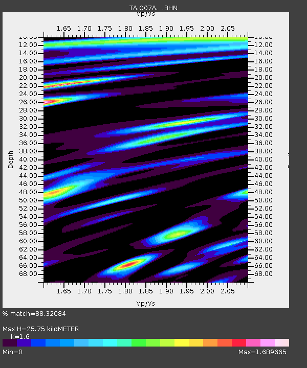
| Estimated Moho Depth: |
25.75 km |
| Estimated Crust Vp/Vs: |
1.60 |
| Assumed Crust Vp: |
6.279 km/s |
| Estimated Crust Vs: |
3.924 km/s |
| Estimated Crust Poisson's Ratio: |
0.18 |
|
| Radial Match: |
88.32084 % |
| Radial Bump: |
400 |
| Transverse Match: |
84.323456 % |
| Transverse Bump: |
400 |
| SOD ConfigId: |
2669 |
| Insert Time: |
2010-03-07 03:21:31.332 +0000 |
| GWidth: |
2.5 |
| Max Bumps: |
400 |
| Tol: |
0.001 |
|
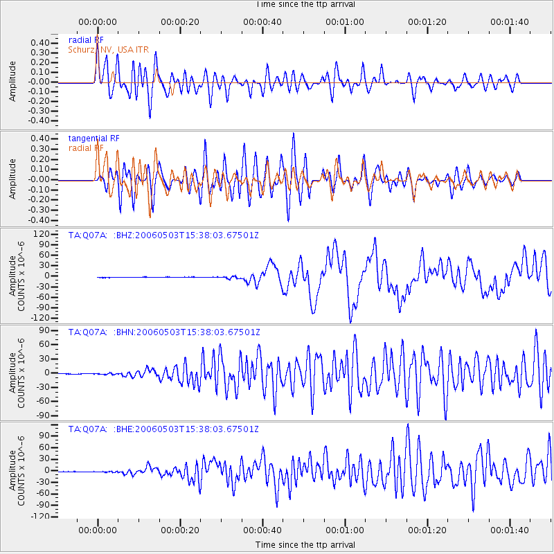
Signal To Noise
| Channel | StoN | STA | LTA |
| TA:Q07A: :BHN:20060503T15:38:03.67501Z | 2.5193932 | 1.0900069E-6 | 4.3264657E-7 |
| TA:Q07A: :BHE:20060503T15:38:03.67501Z | 2.1253145 | 9.3371636E-7 | 4.3933093E-7 |
| TA:Q07A: :BHZ:20060503T15:38:03.67501Z | 6.1751976 | 2.9884316E-6 | 4.8394105E-7 |
| Arrivals |
| Ps | 2.5 SECOND |
| PpPs | 10 SECOND |
| PsPs/PpSs | 13 SECOND |


