You are here: Home > Network List > TA - USArray Transportable Network (new EarthScope stations) Stations List
> Station Q07A Schurz, NV, USA > Earthquake Result Viewer
Q07A Schurz, NV, USA - Earthquake Result Viewer
| Earthquake location: |
Chile-Argentina Border Region |
| Earthquake latitude/longitude: |
-24.4/-67.0 |
| Earthquake time(UTC): |
2006/08/25 (237) 00:44:46 GMT |
| Earthquake Depth: |
184 km |
| Earthquake Magnitude: |
5.9 MB, 6.6 MW, 6.6 MW |
| Earthquake Catalog/Contributor: |
WHDF/NEIC |
|
| Network: |
TA USArray Transportable Network (new EarthScope stations) |
| Station: |
Q07A Schurz, NV, USA |
| Lat/Lon: |
38.94 N/118.81 W |
| Elevation: |
1276 m |
|
| Distance: |
79.5 deg |
| Az: |
321.45 deg |
| Baz: |
133.238 deg |
| Ray Param: |
0.04848101 |
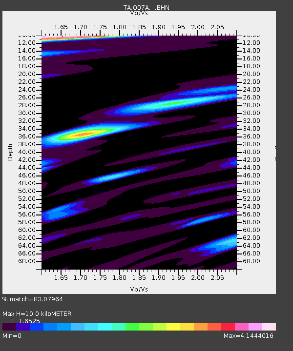
| Estimated Moho Depth: |
10.0 km |
| Estimated Crust Vp/Vs: |
1.65 |
| Assumed Crust Vp: |
6.279 km/s |
| Estimated Crust Vs: |
3.799 km/s |
| Estimated Crust Poisson's Ratio: |
0.21 |
|
| Radial Match: |
83.07964 % |
| Radial Bump: |
400 |
| Transverse Match: |
79.2901 % |
| Transverse Bump: |
400 |
| SOD ConfigId: |
2665 |
| Insert Time: |
2010-03-07 03:21:32.955 +0000 |
| GWidth: |
2.5 |
| Max Bumps: |
400 |
| Tol: |
0.001 |
|
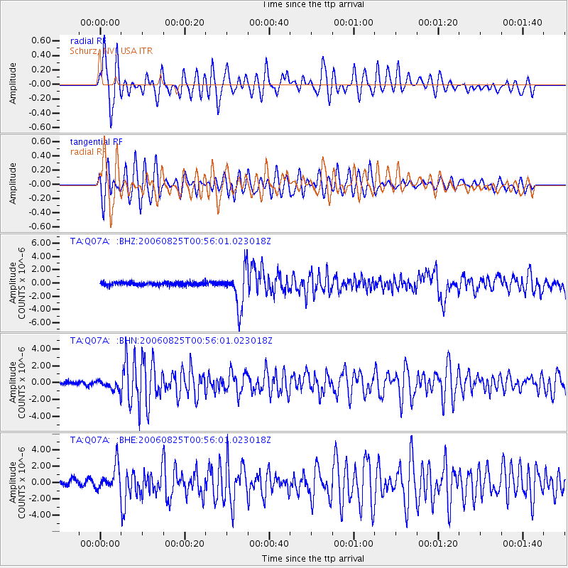
Signal To Noise
| Channel | StoN | STA | LTA |
| TA:Q07A: :BHN:20060825T00:56:01.023018Z | 2.9846218 | 6.1244714E-7 | 2.0520092E-7 |
| TA:Q07A: :BHE:20060825T00:56:01.023018Z | 5.0892653 | 1.5841229E-6 | 3.1126748E-7 |
| TA:Q07A: :BHZ:20060825T00:56:01.023018Z | 11.498392 | 2.9176613E-6 | 2.5374516E-7 |
| Arrivals |
| Ps | 1.1 SECOND |
| PpPs | 4.1 SECOND |
| PsPs/PpSs | 5.2 SECOND |


