You are here: Home > Network List > US - United States National Seismic Network Stations List
> Station HAWA Hanford, Washington, USA > Earthquake Result Viewer
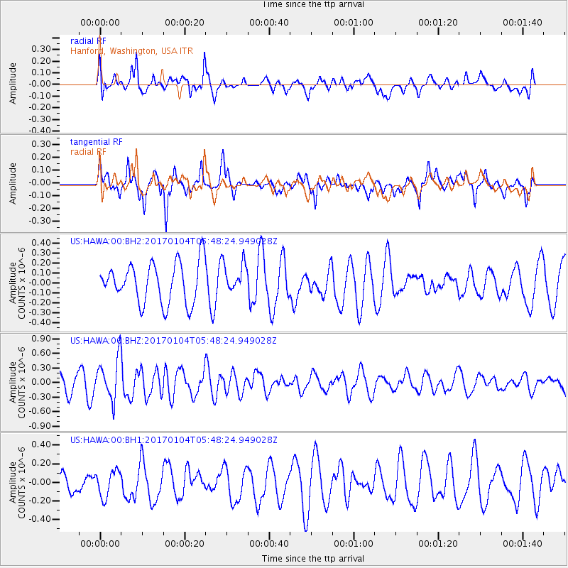
HAWA Hanford, Washington, USA - Earthquake Result Viewer
*The percent match for this event was below the threshold and hence no stack was calculated.
| Earthquake location: |
South Of Fiji Islands |
| Earthquake latitude/longitude: |
-19.2/176.0 |
| Earthquake time(UTC): |
2017/01/04 (004) 05:36:09 GMT |
| Earthquake Depth: |
10 km |
| Earthquake Magnitude: |
5.5 mb |
| Earthquake Catalog/Contributor: |
NEIC PDE/us |
|
| Network: |
US United States National Seismic Network |
| Station: |
HAWA Hanford, Washington, USA |
| Lat/Lon: |
46.39 N/119.53 W |
| Elevation: |
364 m |
|
| Distance: |
87.3 deg |
| Az: |
38.689 deg |
| Baz: |
238.616 deg |
| Ray Param: |
$rayparam |
*The percent match for this event was below the threshold and hence was not used in the summary stack. |
|
| Radial Match: |
48.875523 % |
| Radial Bump: |
400 |
| Transverse Match: |
74.91698 % |
| Transverse Bump: |
400 |
| SOD ConfigId: |
1943534 |
| Insert Time: |
2017-01-18 05:37:46.282 +0000 |
| GWidth: |
2.5 |
| Max Bumps: |
400 |
| Tol: |
0.001 |
|
Signal To Noise
| Channel | StoN | STA | LTA |
| US:HAWA:00:BHZ:20170104T05:48:24.949028Z | 2.8514817 | 4.349133E-7 | 1.5252186E-7 |
| US:HAWA:00:BH1:20170104T05:48:24.949028Z | 1.2159518 | 1.4344114E-7 | 1.17966145E-7 |
| US:HAWA:00:BH2:20170104T05:48:24.949028Z | 0.73221946 | 1.4731145E-7 | 2.0118483E-7 |
| Arrivals |
| Ps | |
| PpPs | |
| PsPs/PpSs | |


