You are here: Home > Network List > TA - USArray Transportable Network (new EarthScope stations) Stations List
> Station ELFS Eagle Lake Field Station, Susanville, CA, USA > Earthquake Result Viewer
ELFS Eagle Lake Field Station, Susanville, CA, USA - Earthquake Result Viewer
| Earthquake location: |
Eastern New Guinea Reg., P.N.G. |
| Earthquake latitude/longitude: |
-5.2/145.3 |
| Earthquake time(UTC): |
2005/11/22 (326) 15:11:31 GMT |
| Earthquake Depth: |
68 km |
| Earthquake Magnitude: |
6.0 MB, 6.2 MW, 6.2 MW |
| Earthquake Catalog/Contributor: |
WHDF/NEIC |
|
| Network: |
TA USArray Transportable Network (new EarthScope stations) |
| Station: |
ELFS Eagle Lake Field Station, Susanville, CA, USA |
| Lat/Lon: |
40.62 N/120.73 W |
| Elevation: |
1553 m |
|
| Distance: |
96.3 deg |
| Az: |
49.824 deg |
| Baz: |
268.674 deg |
| Ray Param: |
0.04049325 |
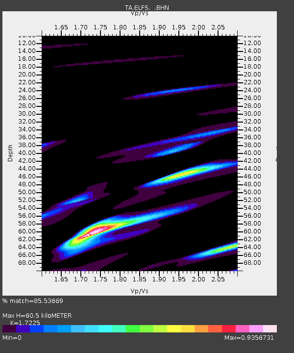
| Estimated Moho Depth: |
60.5 km |
| Estimated Crust Vp/Vs: |
1.72 |
| Assumed Crust Vp: |
6.566 km/s |
| Estimated Crust Vs: |
3.812 km/s |
| Estimated Crust Poisson's Ratio: |
0.25 |
|
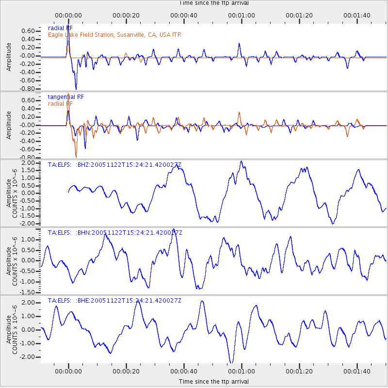
| Radial Match: |
85.53669 % |
| Radial Bump: |
400 |
| Transverse Match: |
83.10774 % |
| Transverse Bump: |
400 |
| SOD ConfigId: |
132717 |
| Insert Time: |
2010-03-07 03:21:37.529 +0000 |
| GWidth: |
2.5 |
| Max Bumps: |
400 |
| Tol: |
0.001 |
|
Signal To Noise
| Channel | StoN | STA | LTA |
| TA:ELFS: :BHN:20051122T15:24:21.420027Z | 2.2910938 | 7.2251E-7 | 3.153559E-7 |
| TA:ELFS: :BHE:20051122T15:24:21.420027Z | 1.8118069 | 1.1416876E-6 | 6.301376E-7 |
| TA:ELFS: :BHZ:20051122T15:24:21.420027Z | 1.2707461 | 7.071097E-7 | 5.5645233E-7 |
| Arrivals |
| Ps | 6.8 SECOND |
| PpPs | 25 SECOND |
| PsPs/PpSs | 31 SECOND |


