You are here: Home > Network List > TA - USArray Transportable Network (new EarthScope stations) Stations List
> Station ELFS Eagle Lake Field Station, Susanville, CA, USA > Earthquake Result Viewer
ELFS Eagle Lake Field Station, Susanville, CA, USA - Earthquake Result Viewer
| Earthquake location: |
Southeastern Siberia, Russia |
| Earthquake latitude/longitude: |
57.5/120.6 |
| Earthquake time(UTC): |
2005/11/10 (314) 19:29:54 GMT |
| Earthquake Depth: |
6.0 km |
| Earthquake Magnitude: |
5.9 MB, 5.7 MS, 5.9 MW, 5.9 MW |
| Earthquake Catalog/Contributor: |
WHDF/NEIC |
|
| Network: |
TA USArray Transportable Network (new EarthScope stations) |
| Station: |
ELFS Eagle Lake Field Station, Susanville, CA, USA |
| Lat/Lon: |
40.62 N/120.73 W |
| Elevation: |
1553 m |
|
| Distance: |
69.6 deg |
| Az: |
45.429 deg |
| Baz: |
329.626 deg |
| Ray Param: |
0.05553545 |
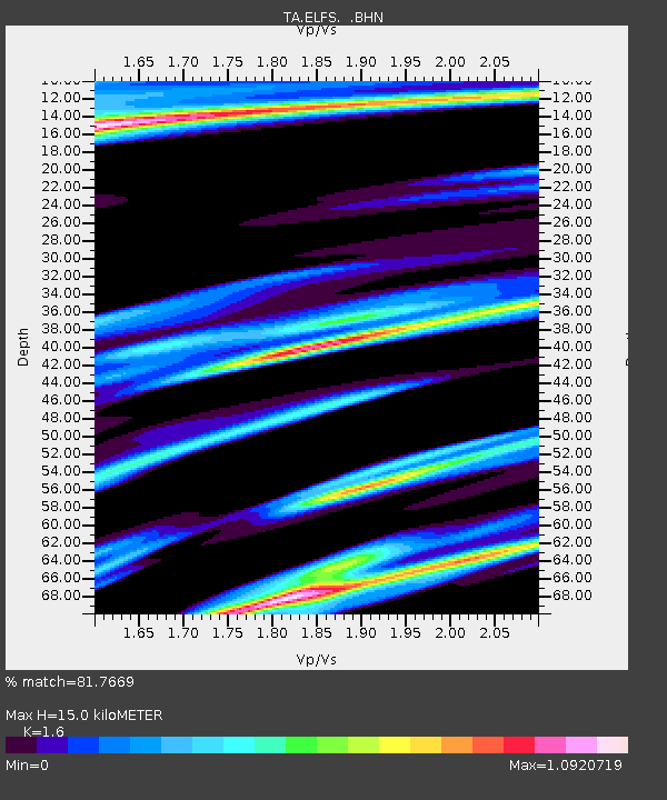
| Estimated Moho Depth: |
15.0 km |
| Estimated Crust Vp/Vs: |
1.60 |
| Assumed Crust Vp: |
6.566 km/s |
| Estimated Crust Vs: |
4.104 km/s |
| Estimated Crust Poisson's Ratio: |
0.18 |
|
| Radial Match: |
81.7669 % |
| Radial Bump: |
400 |
| Transverse Match: |
67.90126 % |
| Transverse Bump: |
400 |
| SOD ConfigId: |
2448 |
| Insert Time: |
2010-03-07 03:21:46.052 +0000 |
| GWidth: |
2.5 |
| Max Bumps: |
400 |
| Tol: |
0.001 |
|
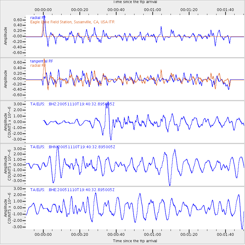
Signal To Noise
| Channel | StoN | STA | LTA |
| TA:ELFS: :BHN:20051110T19:40:32.895005Z | 1.7803137 | 8.103365E-7 | 4.5516498E-7 |
| TA:ELFS: :BHE:20051110T19:40:32.895005Z | 0.6664869 | 3.2398296E-7 | 4.8610553E-7 |
| TA:ELFS: :BHZ:20051110T19:40:32.895005Z | 5.713802 | 1.3601438E-6 | 2.380453E-7 |
| Arrivals |
| Ps | 1.4 SECOND |
| PpPs | 5.7 SECOND |
| PsPs/PpSs | 7.1 SECOND |


