You are here: Home > Network List > TA - USArray Transportable Network (new EarthScope stations) Stations List
> Station ELFS Eagle Lake Field Station, Susanville, CA, USA > Earthquake Result Viewer
ELFS Eagle Lake Field Station, Susanville, CA, USA - Earthquake Result Viewer
| Earthquake location: |
Rat Islands, Aleutian Islands |
| Earthquake latitude/longitude: |
51.2/179.4 |
| Earthquake time(UTC): |
2005/06/14 (165) 17:10:16 GMT |
| Earthquake Depth: |
51 km |
| Earthquake Magnitude: |
6.0 MB, 6.8 MW, 6.6 MW |
| Earthquake Catalog/Contributor: |
WHDF/NEIC |
|
| Network: |
TA USArray Transportable Network (new EarthScope stations) |
| Station: |
ELFS Eagle Lake Field Station, Susanville, CA, USA |
| Lat/Lon: |
40.62 N/120.73 W |
| Elevation: |
1553 m |
|
| Distance: |
41.9 deg |
| Az: |
80.467 deg |
| Baz: |
305.458 deg |
| Ray Param: |
0.07336822 |
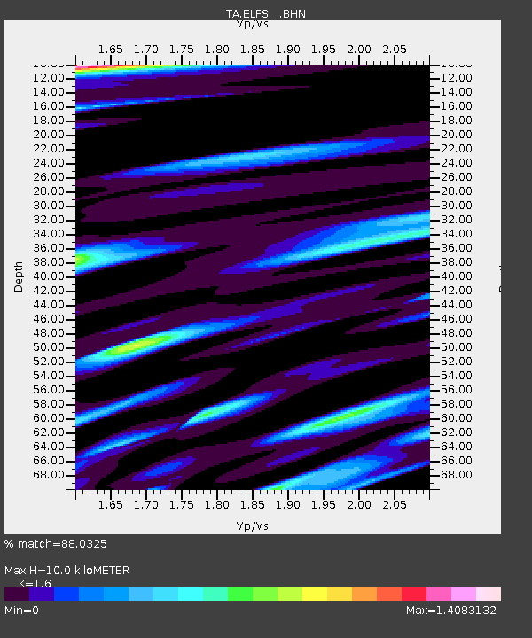
| Estimated Moho Depth: |
10.0 km |
| Estimated Crust Vp/Vs: |
1.60 |
| Assumed Crust Vp: |
6.566 km/s |
| Estimated Crust Vs: |
4.104 km/s |
| Estimated Crust Poisson's Ratio: |
0.18 |
|
| Radial Match: |
88.0325 % |
| Radial Bump: |
400 |
| Transverse Match: |
75.67294 % |
| Transverse Bump: |
400 |
| SOD ConfigId: |
144822 |
| Insert Time: |
2010-03-07 03:21:47.774 +0000 |
| GWidth: |
2.5 |
| Max Bumps: |
400 |
| Tol: |
0.001 |
|
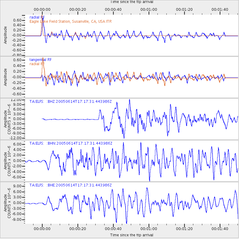
Signal To Noise
| Channel | StoN | STA | LTA |
| TA:ELFS: :BHN:20050614T17:17:31.443986Z | 6.6157537 | 1.3154007E-6 | 1.9882856E-7 |
| TA:ELFS: :BHE:20050614T17:17:31.443986Z | 5.6183357 | 1.4832895E-6 | 2.640087E-7 |
| TA:ELFS: :BHZ:20050614T17:17:31.443986Z | 16.874939 | 2.3700925E-6 | 1.4045044E-7 |
| Arrivals |
| Ps | 1.0 SECOND |
| PpPs | 3.7 SECOND |
| PsPs/PpSs | 4.6 SECOND |


