You are here: Home > Network List > TA - USArray Transportable Network (new EarthScope stations) Stations List
> Station ELFS Eagle Lake Field Station, Susanville, CA, USA > Earthquake Result Viewer
ELFS Eagle Lake Field Station, Susanville, CA, USA - Earthquake Result Viewer
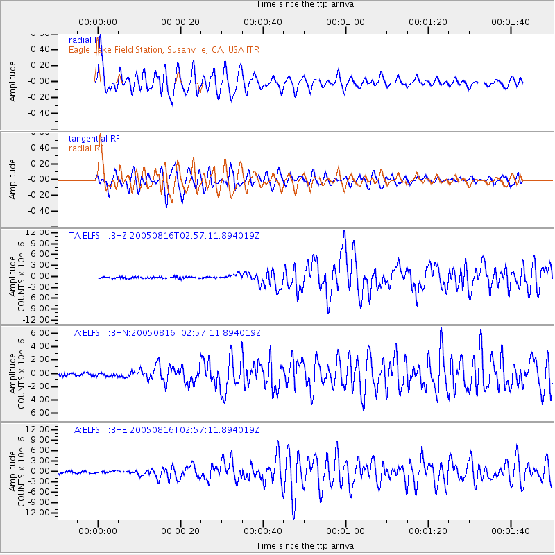
| Earthquake location: |
Near East Coast Of Honshu, Japan |
| Earthquake latitude/longitude: |
38.3/142.0 |
| Earthquake time(UTC): |
2005/08/16 (228) 02:46:28 GMT |
| Earthquake Depth: |
36 km |
| Earthquake Magnitude: |
6.5 MB, 6.8 MS, 7.2 MW, 7.1 MW |
| Earthquake Catalog/Contributor: |
WHDF/NEIC |
|
| Network: |
TA USArray Transportable Network (new EarthScope stations) |
| Station: |
ELFS Eagle Lake Field Station, Susanville, CA, USA |
| Lat/Lon: |
40.62 N/120.73 W |
| Elevation: |
1553 m |
|
| Distance: |
71.1 deg |
| Az: |
52.977 deg |
| Baz: |
304.361 deg |
| Ray Param: |
0.054515243 |
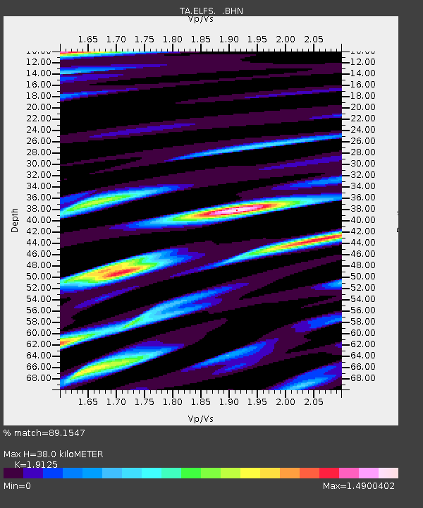
| Estimated Moho Depth: |
38.0 km |
| Estimated Crust Vp/Vs: |
1.91 |
| Assumed Crust Vp: |
6.566 km/s |
| Estimated Crust Vs: |
3.433 km/s |
| Estimated Crust Poisson's Ratio: |
0.31 |
|
| Radial Match: |
89.1547 % |
| Radial Bump: |
400 |
| Transverse Match: |
84.55699 % |
| Transverse Bump: |
400 |
| SOD ConfigId: |
2475 |
| Insert Time: |
2010-03-07 03:21:55.423 +0000 |
| GWidth: |
2.5 |
| Max Bumps: |
400 |
| Tol: |
0.001 |
|
Signal To Noise
| Channel | StoN | STA | LTA |
| TA:ELFS: :BHN:20050816T02:57:11.894019Z | 1.2891871 | 2.2508627E-7 | 1.745955E-7 |
| TA:ELFS: :BHE:20050816T02:57:11.894019Z | 0.8655768 | 2.9966043E-7 | 3.461974E-7 |
| TA:ELFS: :BHZ:20050816T02:57:11.894019Z | 3.505888 | 6.856941E-7 | 1.9558357E-7 |
| Arrivals |
| Ps | 5.5 SECOND |
| PpPs | 16 SECOND |
| PsPs/PpSs | 22 SECOND |


