You are here: Home > Network List > TA - USArray Transportable Network (new EarthScope stations) Stations List
> Station ELFS Eagle Lake Field Station, Susanville, CA, USA > Earthquake Result Viewer
ELFS Eagle Lake Field Station, Susanville, CA, USA - Earthquake Result Viewer
| Earthquake location: |
Kuril Islands |
| Earthquake latitude/longitude: |
45.8/150.1 |
| Earthquake time(UTC): |
2007/09/03 (246) 16:14:53 GMT |
| Earthquake Depth: |
94 km |
| Earthquake Magnitude: |
6.3 MB, 6.2 MW, 6.2 ME |
| Earthquake Catalog/Contributor: |
WHDF/NEIC |
|
| Network: |
TA USArray Transportable Network (new EarthScope stations) |
| Station: |
ELFS Eagle Lake Field Station, Susanville, CA, USA |
| Lat/Lon: |
40.62 N/120.73 W |
| Elevation: |
1553 m |
|
| Distance: |
61.9 deg |
| Az: |
59.638 deg |
| Baz: |
307.584 deg |
| Ray Param: |
0.060321353 |
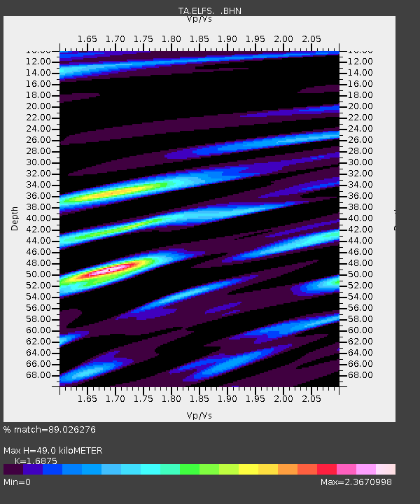
| Estimated Moho Depth: |
49.0 km |
| Estimated Crust Vp/Vs: |
1.69 |
| Assumed Crust Vp: |
6.566 km/s |
| Estimated Crust Vs: |
3.891 km/s |
| Estimated Crust Poisson's Ratio: |
0.23 |
|
| Radial Match: |
89.026276 % |
| Radial Bump: |
400 |
| Transverse Match: |
81.974 % |
| Transverse Bump: |
385 |
| SOD ConfigId: |
2564 |
| Insert Time: |
2010-03-07 03:22:06.644 +0000 |
| GWidth: |
2.5 |
| Max Bumps: |
400 |
| Tol: |
0.001 |
|
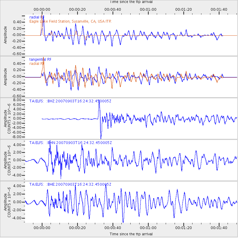
Signal To Noise
| Channel | StoN | STA | LTA |
| TA:ELFS: :BHN:20070903T16:24:32.450005Z | 8.227389 | 1.7605514E-6 | 2.1398664E-7 |
| TA:ELFS: :BHE:20070903T16:24:32.450005Z | 5.551968 | 1.5086366E-6 | 2.7173004E-7 |
| TA:ELFS: :BHZ:20070903T16:24:32.450005Z | 30.447008 | 3.6517154E-6 | 1.1993676E-7 |
| Arrivals |
| Ps | 5.4 SECOND |
| PpPs | 19 SECOND |
| PsPs/PpSs | 24 SECOND |


