You are here: Home > Network List > TA - USArray Transportable Network (new EarthScope stations) Stations List
> Station ELFS Eagle Lake Field Station, Susanville, CA, USA > Earthquake Result Viewer
ELFS Eagle Lake Field Station, Susanville, CA, USA - Earthquake Result Viewer
| Earthquake location: |
Solomon Islands |
| Earthquake latitude/longitude: |
-7.3/155.6 |
| Earthquake time(UTC): |
2007/04/01 (091) 21:45:37 GMT |
| Earthquake Depth: |
10 km |
| Earthquake Magnitude: |
5.7 MB |
| Earthquake Catalog/Contributor: |
WHDF/NEIC |
|
| Network: |
TA USArray Transportable Network (new EarthScope stations) |
| Station: |
ELFS Eagle Lake Field Station, Susanville, CA, USA |
| Lat/Lon: |
40.62 N/120.73 W |
| Elevation: |
1553 m |
|
| Distance: |
89.9 deg |
| Az: |
49.158 deg |
| Baz: |
260.337 deg |
| Ray Param: |
0.041711327 |
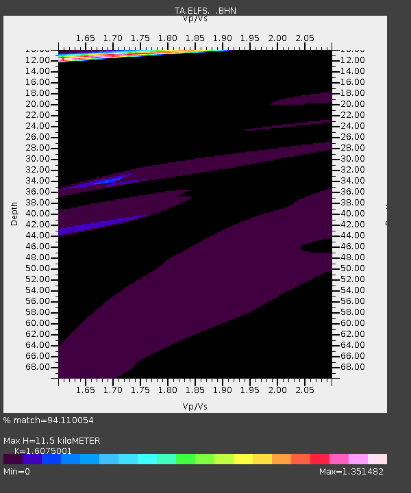
| Estimated Moho Depth: |
11.5 km |
| Estimated Crust Vp/Vs: |
1.61 |
| Assumed Crust Vp: |
6.566 km/s |
| Estimated Crust Vs: |
4.085 km/s |
| Estimated Crust Poisson's Ratio: |
0.18 |
|
| Radial Match: |
94.110054 % |
| Radial Bump: |
400 |
| Transverse Match: |
82.46516 % |
| Transverse Bump: |
372 |
| SOD ConfigId: |
2564 |
| Insert Time: |
2010-03-07 03:22:25.125 +0000 |
| GWidth: |
2.5 |
| Max Bumps: |
400 |
| Tol: |
0.001 |
|
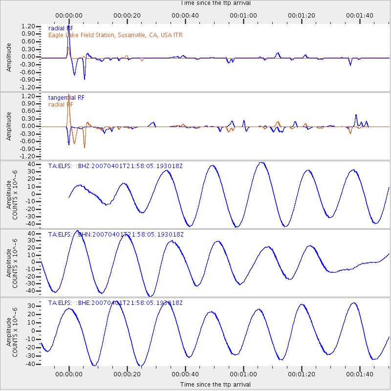
Signal To Noise
| Channel | StoN | STA | LTA |
| TA:ELFS: :BHN:20070401T21:58:05.193018Z | 1.490765 | 3.4591336E-5 | 2.320375E-5 |
| TA:ELFS: :BHE:20070401T21:58:05.193018Z | 1.7267206 | 2.4465027E-5 | 1.4168491E-5 |
| TA:ELFS: :BHZ:20070401T21:58:05.193018Z | 2.3858466 | 2.4722232E-5 | 1.0362038E-5 |
| Arrivals |
| Ps | 1.1 SECOND |
| PpPs | 4.5 SECOND |
| PsPs/PpSs | 5.5 SECOND |


