You are here: Home > Network List > TA - USArray Transportable Network (new EarthScope stations) Stations List
> Station ELFS Eagle Lake Field Station, Susanville, CA, USA > Earthquake Result Viewer
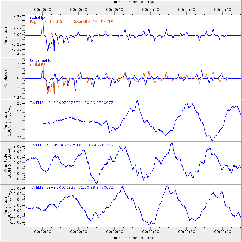
ELFS Eagle Lake Field Station, Susanville, CA, USA - Earthquake Result Viewer
| Earthquake location: |
Vanuatu Islands |
| Earthquake latitude/longitude: |
-20.8/169.4 |
| Earthquake time(UTC): |
2007/03/25 (084) 01:08:19 GMT |
| Earthquake Depth: |
35 km |
| Earthquake Magnitude: |
5.9 MB, 7.1 MS, 6.9 MW |
| Earthquake Catalog/Contributor: |
WHDF/NEIC |
|
| Network: |
TA USArray Transportable Network (new EarthScope stations) |
| Station: |
ELFS Eagle Lake Field Station, Susanville, CA, USA |
| Lat/Lon: |
40.62 N/120.73 W |
| Elevation: |
1553 m |
|
| Distance: |
89.1 deg |
| Az: |
45.646 deg |
| Baz: |
241.535 deg |
| Ray Param: |
0.04207094 |
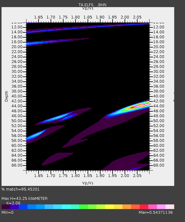
| Estimated Moho Depth: |
43.25 km |
| Estimated Crust Vp/Vs: |
2.08 |
| Assumed Crust Vp: |
6.566 km/s |
| Estimated Crust Vs: |
3.157 km/s |
| Estimated Crust Poisson's Ratio: |
0.35 |
|
| Radial Match: |
95.45201 % |
| Radial Bump: |
400 |
| Transverse Match: |
50.410122 % |
| Transverse Bump: |
400 |
| SOD ConfigId: |
2564 |
| Insert Time: |
2010-03-07 03:22:28.991 +0000 |
| GWidth: |
2.5 |
| Max Bumps: |
400 |
| Tol: |
0.001 |
|
Signal To Noise
| Channel | StoN | STA | LTA |
| TA:ELFS: :BHN:20070325T01:20:39.370007Z | 2.3080273 | 3.439169E-6 | 1.4900902E-6 |
| TA:ELFS: :BHE:20070325T01:20:39.370007Z | 1.3815119 | 2.7622284E-6 | 1.9994243E-6 |
| TA:ELFS: :BHZ:20070325T01:20:39.370007Z | 1.5491073 | 3.2278442E-6 | 2.0836803E-6 |
| Arrivals |
| Ps | 7.2 SECOND |
| PpPs | 20 SECOND |
| PsPs/PpSs | 27 SECOND |


