You are here: Home > Network List > TA - USArray Transportable Network (new EarthScope stations) Stations List
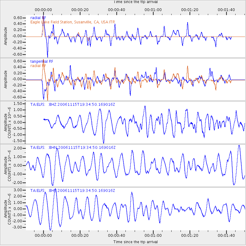
> Station ELFS Eagle Lake Field Station, Susanville, CA, USA > Earthquake Result Viewer
ELFS Eagle Lake Field Station, Susanville, CA, USA - Earthquake Result Viewer
| Earthquake location: |
Kuril Islands |
| Earthquake latitude/longitude: |
47.0/155.0 |
| Earthquake time(UTC): |
2006/11/15 (319) 19:25:25 GMT |
| Earthquake Depth: |
10 km |
| Earthquake Magnitude: |
5.6 MB, 5.6 MS |
| Earthquake Catalog/Contributor: |
WHDF/NEIC |
|
| Network: |
TA USArray Transportable Network (new EarthScope stations) |
| Station: |
ELFS Eagle Lake Field Station, Susanville, CA, USA |
| Lat/Lon: |
40.62 N/120.73 W |
| Elevation: |
1553 m |
|
| Distance: |
58.4 deg |
| Az: |
62.839 deg |
| Baz: |
306.879 deg |
| Ray Param: |
0.06289811 |
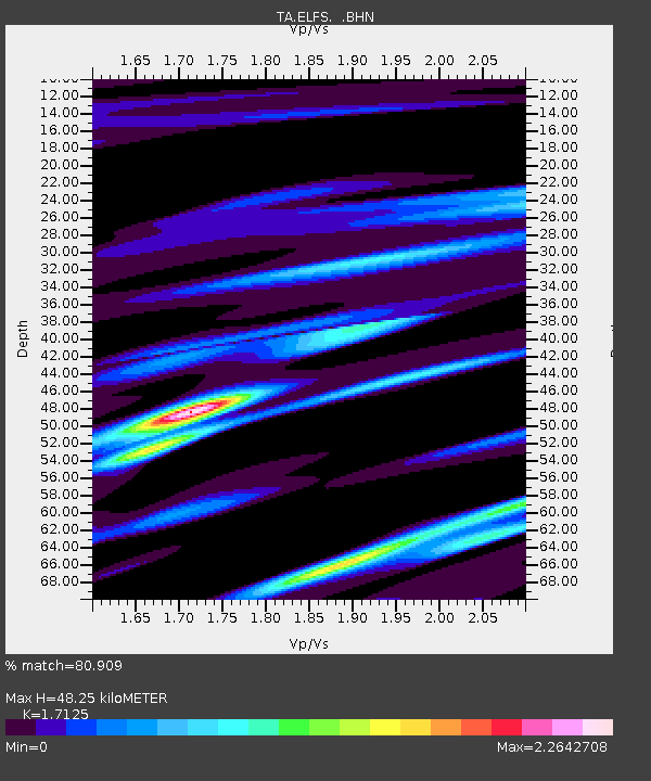
| Estimated Moho Depth: |
48.25 km |
| Estimated Crust Vp/Vs: |
1.71 |
| Assumed Crust Vp: |
6.566 km/s |
| Estimated Crust Vs: |
3.834 km/s |
| Estimated Crust Poisson's Ratio: |
0.24 |
|
| Radial Match: |
80.909 % |
| Radial Bump: |
334 |
| Transverse Match: |
60.57548 % |
| Transverse Bump: |
400 |
| SOD ConfigId: |
2564 |
| Insert Time: |
2010-03-07 03:22:43.657 +0000 |
| GWidth: |
2.5 |
| Max Bumps: |
400 |
| Tol: |
0.001 |
|
Signal To Noise
| Channel | StoN | STA | LTA |
| TA:ELFS: :BHN:20061115T19:34:50.169016Z | 1.6894958 | 1.1348935E-6 | 6.7173505E-7 |
| TA:ELFS: :BHE:20061115T19:34:50.169016Z | 3.3482678 | 2.0934017E-6 | 6.252193E-7 |
| TA:ELFS: :BHZ:20061115T19:34:50.169016Z | 2.484186 | 8.3138696E-7 | 3.346718E-7 |
| Arrivals |
| Ps | 5.5 SECOND |
| PpPs | 19 SECOND |
| PsPs/PpSs | 24 SECOND |


