You are here: Home > Network List > TA - USArray Transportable Network (new EarthScope stations) Stations List
> Station ELFS Eagle Lake Field Station, Susanville, CA, USA > Earthquake Result Viewer
ELFS Eagle Lake Field Station, Susanville, CA, USA - Earthquake Result Viewer
| Earthquake location: |
Bonin Islands, Japan Region |
| Earthquake latitude/longitude: |
26.1/144.0 |
| Earthquake time(UTC): |
2006/08/06 (218) 18:16:40 GMT |
| Earthquake Depth: |
23 km |
| Earthquake Magnitude: |
6.0 MB, 5.6 MS, 5.8 MW, 5.8 MW |
| Earthquake Catalog/Contributor: |
WHDF/NEIC |
|
| Network: |
TA USArray Transportable Network (new EarthScope stations) |
| Station: |
ELFS Eagle Lake Field Station, Susanville, CA, USA |
| Lat/Lon: |
40.62 N/120.73 W |
| Elevation: |
1553 m |
|
| Distance: |
77.2 deg |
| Az: |
51.01 deg |
| Baz: |
293.368 deg |
| Ray Param: |
0.050443415 |
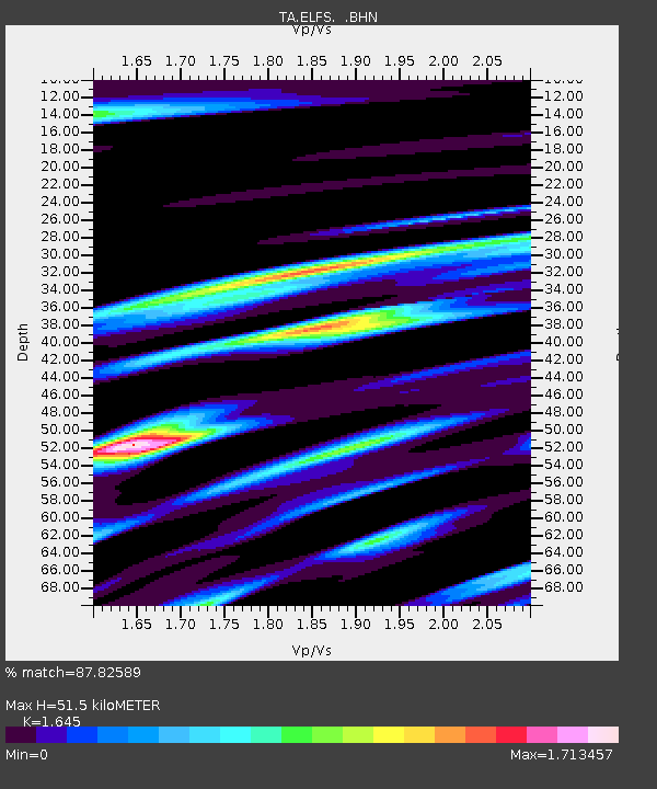
| Estimated Moho Depth: |
51.5 km |
| Estimated Crust Vp/Vs: |
1.64 |
| Assumed Crust Vp: |
6.566 km/s |
| Estimated Crust Vs: |
3.992 km/s |
| Estimated Crust Poisson's Ratio: |
0.21 |
|
| Radial Match: |
87.82589 % |
| Radial Bump: |
400 |
| Transverse Match: |
80.40307 % |
| Transverse Bump: |
400 |
| SOD ConfigId: |
2665 |
| Insert Time: |
2010-03-07 03:23:06.022 +0000 |
| GWidth: |
2.5 |
| Max Bumps: |
400 |
| Tol: |
0.001 |
|
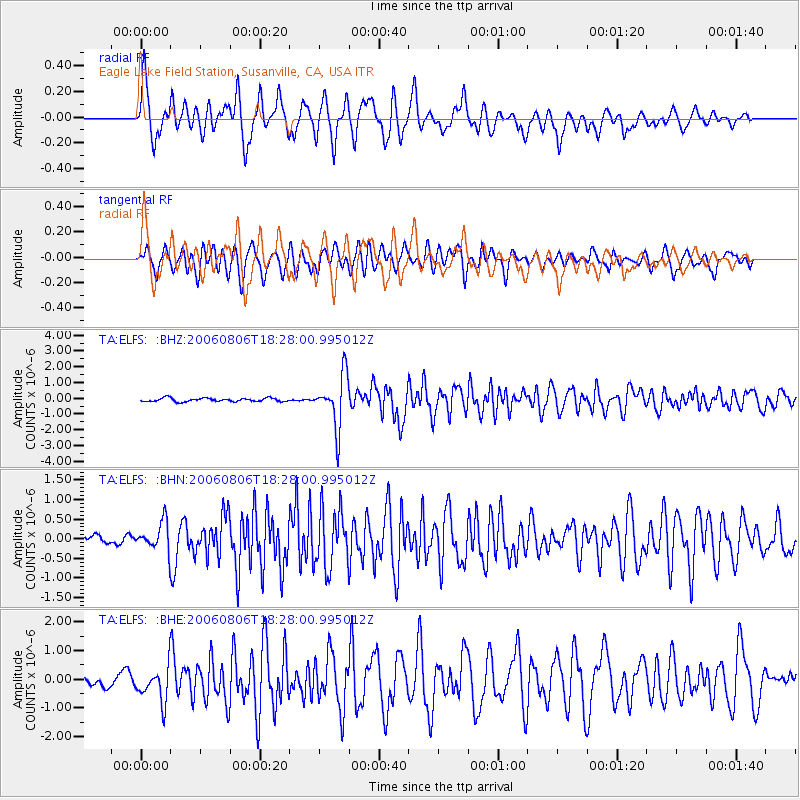
Signal To Noise
| Channel | StoN | STA | LTA |
| TA:ELFS: :BHN:20060806T18:28:00.995012Z | 3.055926 | 3.6502024E-7 | 1.1944668E-7 |
| TA:ELFS: :BHE:20060806T18:28:00.995012Z | 3.876535 | 6.089046E-7 | 1.5707444E-7 |
| TA:ELFS: :BHZ:20060806T18:28:00.995012Z | 14.9966345 | 1.6489997E-6 | 1.0995799E-7 |
| Arrivals |
| Ps | 5.2 SECOND |
| PpPs | 20 SECOND |
| PsPs/PpSs | 25 SECOND |


