You are here: Home > Network List > TA - USArray Transportable Network (new EarthScope stations) Stations List
> Station ELFS Eagle Lake Field Station, Susanville, CA, USA > Earthquake Result Viewer
ELFS Eagle Lake Field Station, Susanville, CA, USA - Earthquake Result Viewer
| Earthquake location: |
Eastern Siberia, Russia |
| Earthquake latitude/longitude: |
60.5/167.5 |
| Earthquake time(UTC): |
2006/04/29 (119) 16:58:06 GMT |
| Earthquake Depth: |
11 km |
| Earthquake Magnitude: |
6.4 MB, 6.6 MS, 6.6 MW, 6.4 MW |
| Earthquake Catalog/Contributor: |
WHDF/NEIC |
|
| Network: |
TA USArray Transportable Network (new EarthScope stations) |
| Station: |
ELFS Eagle Lake Field Station, Susanville, CA, USA |
| Lat/Lon: |
40.62 N/120.73 W |
| Elevation: |
1553 m |
|
| Distance: |
47.0 deg |
| Az: |
81.04 deg |
| Baz: |
320.027 deg |
| Ray Param: |
0.070249096 |
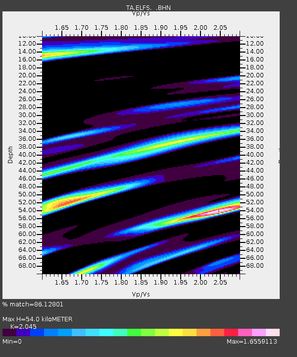
| Estimated Moho Depth: |
54.0 km |
| Estimated Crust Vp/Vs: |
2.05 |
| Assumed Crust Vp: |
6.566 km/s |
| Estimated Crust Vs: |
3.211 km/s |
| Estimated Crust Poisson's Ratio: |
0.34 |
|
| Radial Match: |
86.12801 % |
| Radial Bump: |
400 |
| Transverse Match: |
75.02511 % |
| Transverse Bump: |
400 |
| SOD ConfigId: |
2669 |
| Insert Time: |
2010-03-07 03:23:17.978 +0000 |
| GWidth: |
2.5 |
| Max Bumps: |
400 |
| Tol: |
0.001 |
|
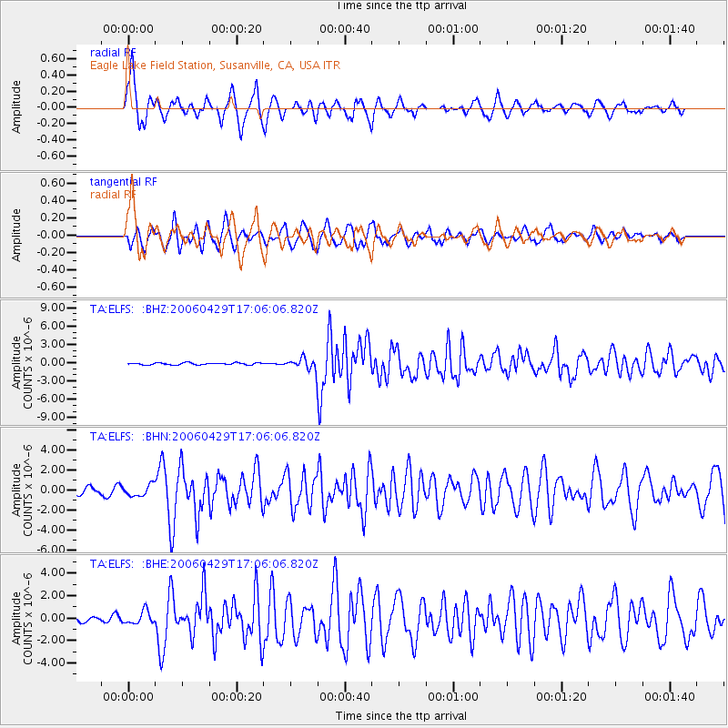
Signal To Noise
| Channel | StoN | STA | LTA |
| TA:ELFS: :BHN:20060429T17:06:06.820Z | 1.75616 | 5.57657E-7 | 3.175434E-7 |
| TA:ELFS: :BHE:20060429T17:06:06.820Z | 1.7300814 | 5.841864E-7 | 3.3766412E-7 |
| TA:ELFS: :BHZ:20060429T17:06:06.820Z | 5.79208 | 9.654074E-7 | 1.6667714E-7 |
| Arrivals |
| Ps | 9.1 SECOND |
| PpPs | 24 SECOND |
| PsPs/PpSs | 33 SECOND |


