You are here: Home > Network List > TA - USArray Transportable Network (new EarthScope stations) Stations List
> Station E20K Nigu River, AK, USA > Earthquake Result Viewer
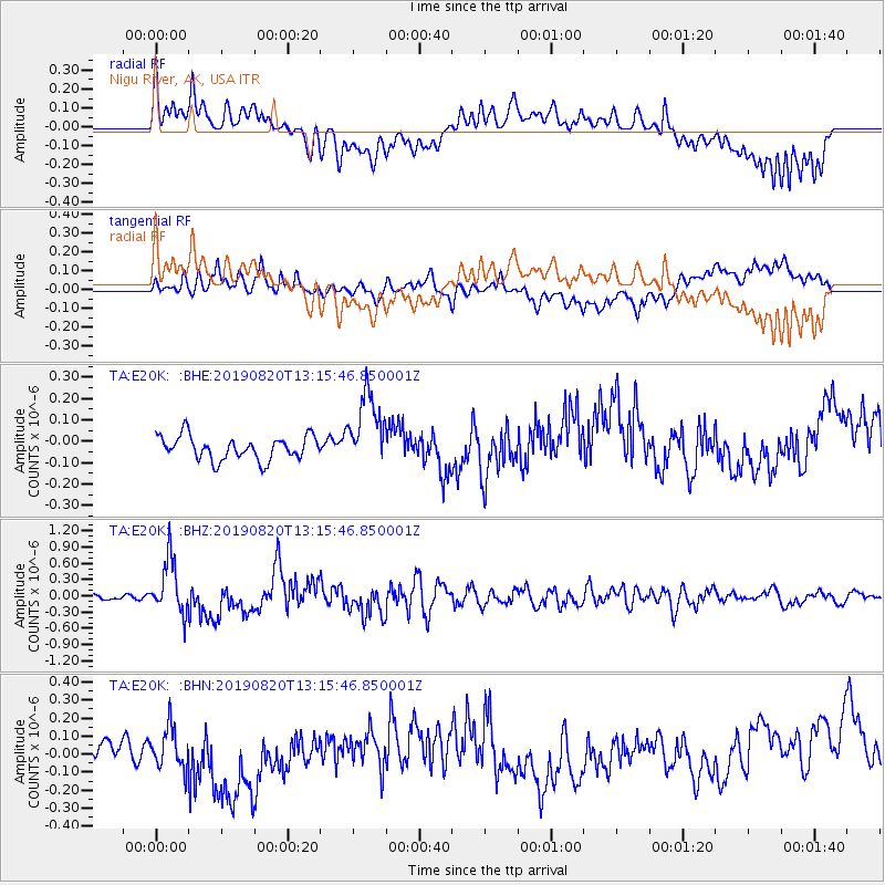
E20K Nigu River, AK, USA - Earthquake Result Viewer
*The percent match for this event was below the threshold and hence no stack was calculated.
| Earthquake location: |
Santa Cruz Islands |
| Earthquake latitude/longitude: |
-11.4/166.3 |
| Earthquake time(UTC): |
2019/08/20 (232) 13:03:52 GMT |
| Earthquake Depth: |
37 km |
| Earthquake Magnitude: |
6.0 Mww |
| Earthquake Catalog/Contributor: |
NEIC PDE/us |
|
| Network: |
TA USArray Transportable Network (new EarthScope stations) |
| Station: |
E20K Nigu River, AK, USA |
| Lat/Lon: |
68.26 N/156.19 W |
| Elevation: |
866 m |
|
| Distance: |
83.8 deg |
| Az: |
13.192 deg |
| Baz: |
216.92 deg |
| Ray Param: |
$rayparam |
*The percent match for this event was below the threshold and hence was not used in the summary stack. |
|
| Radial Match: |
73.40978 % |
| Radial Bump: |
400 |
| Transverse Match: |
71.870865 % |
| Transverse Bump: |
400 |
| SOD ConfigId: |
19053131 |
| Insert Time: |
2019-09-03 13:09:54.134 +0000 |
| GWidth: |
2.5 |
| Max Bumps: |
400 |
| Tol: |
0.001 |
|
Signal To Noise
| Channel | StoN | STA | LTA |
| TA:E20K: :BHZ:20190820T13:15:46.850001Z | 11.020571 | 5.0480617E-7 | 4.580581E-8 |
| TA:E20K: :BHN:20190820T13:15:46.850001Z | 2.2464194 | 1.1195178E-7 | 4.9835652E-8 |
| TA:E20K: :BHE:20190820T13:15:46.850001Z | 3.210226 | 1.775245E-7 | 5.529969E-8 |
| Arrivals |
| Ps | |
| PpPs | |
| PsPs/PpSs | |


