You are here: Home > Network List > TS - TERRAscope (Southern California Seismic Network) Stations List
> Station MLAC Mammoth Lakes, California, USA > Earthquake Result Viewer
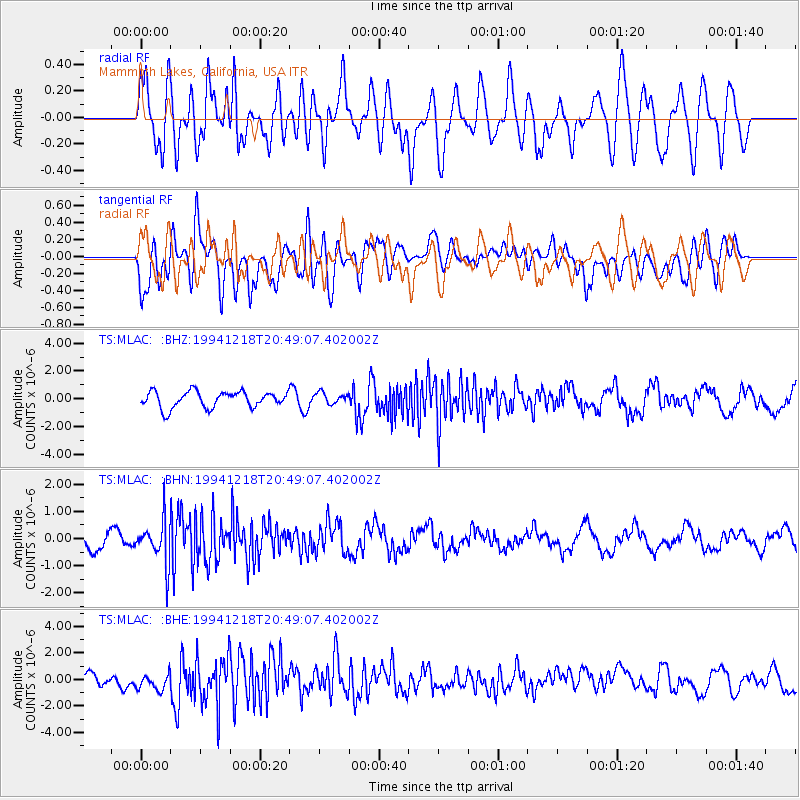
MLAC Mammoth Lakes, California, USA - Earthquake Result Viewer
*The percent match for this event was below the threshold and hence no stack was calculated.
| Earthquake location: |
Fiji Islands Region |
| Earthquake latitude/longitude: |
-17.9/-178.7 |
| Earthquake time(UTC): |
1994/12/18 (352) 20:38:32 GMT |
| Earthquake Depth: |
551 km |
| Earthquake Magnitude: |
5.6 MB, 5.8 UNKNOWN, 5.7 MW |
| Earthquake Catalog/Contributor: |
WHDF/NEIC |
|
| Network: |
TS TERRAscope (Southern California Seismic Network) |
| Station: |
MLAC Mammoth Lakes, California, USA |
| Lat/Lon: |
37.63 N/118.83 W |
| Elevation: |
2170 m |
|
| Distance: |
78.8 deg |
| Az: |
44.421 deg |
| Baz: |
237.102 deg |
| Ray Param: |
$rayparam |
*The percent match for this event was below the threshold and hence was not used in the summary stack. |
|
| Radial Match: |
37.300175 % |
| Radial Bump: |
400 |
| Transverse Match: |
44.818085 % |
| Transverse Bump: |
400 |
| SOD ConfigId: |
4480 |
| Insert Time: |
2010-02-26 14:26:05.484 +0000 |
| GWidth: |
2.5 |
| Max Bumps: |
400 |
| Tol: |
0.001 |
|
Signal To Noise
| Channel | StoN | STA | LTA |
| TS:MLAC: :BHN:19941218T20:49:07.402002Z | 2.9499044 | 8.108607E-7 | 2.7487695E-7 |
| TS:MLAC: :BHE:19941218T20:49:07.402002Z | 0.79200524 | 5.7753164E-7 | 7.2920176E-7 |
| TS:MLAC: :BHZ:19941218T20:49:07.402002Z | 0.6834579 | 3.9847552E-7 | 5.830286E-7 |
| Arrivals |
| Ps | |
| PpPs | |
| PsPs/PpSs | |


