You are here: Home > Network List > TA - USArray Transportable Network (new EarthScope stations) Stations List
> Station G21K Allakaket, AK, USA > Earthquake Result Viewer
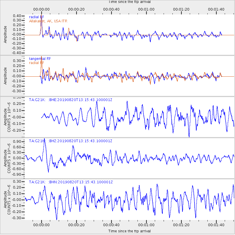
G21K Allakaket, AK, USA - Earthquake Result Viewer
*The percent match for this event was below the threshold and hence no stack was calculated.
| Earthquake location: |
Santa Cruz Islands |
| Earthquake latitude/longitude: |
-11.4/166.3 |
| Earthquake time(UTC): |
2019/08/20 (232) 13:03:52 GMT |
| Earthquake Depth: |
37 km |
| Earthquake Magnitude: |
6.0 Mww |
| Earthquake Catalog/Contributor: |
NEIC PDE/us |
|
| Network: |
TA USArray Transportable Network (new EarthScope stations) |
| Station: |
G21K Allakaket, AK, USA |
| Lat/Lon: |
66.52 N/153.51 W |
| Elevation: |
446 m |
|
| Distance: |
83.1 deg |
| Az: |
15.103 deg |
| Baz: |
219.614 deg |
| Ray Param: |
$rayparam |
*The percent match for this event was below the threshold and hence was not used in the summary stack. |
|
| Radial Match: |
79.92207 % |
| Radial Bump: |
367 |
| Transverse Match: |
69.815926 % |
| Transverse Bump: |
400 |
| SOD ConfigId: |
19053131 |
| Insert Time: |
2019-09-03 13:10:10.777 +0000 |
| GWidth: |
2.5 |
| Max Bumps: |
400 |
| Tol: |
0.001 |
|
Signal To Noise
| Channel | StoN | STA | LTA |
| TA:G21K: :BHZ:20190820T13:15:43.100001Z | 6.0400558 | 5.0734536E-7 | 8.39968E-8 |
| TA:G21K: :BHN:20190820T13:15:43.100001Z | 3.1487498 | 1.205934E-7 | 3.829882E-8 |
| TA:G21K: :BHE:20190820T13:15:43.100001Z | 1.8537157 | 1.0674363E-7 | 5.7583602E-8 |
| Arrivals |
| Ps | |
| PpPs | |
| PsPs/PpSs | |


