You are here: Home > Network List > TA - USArray Transportable Network (new EarthScope stations) Stations List
> Station G22K Bettles, AK, USA > Earthquake Result Viewer
G22K Bettles, AK, USA - Earthquake Result Viewer
| Earthquake location: |
Santa Cruz Islands |
| Earthquake latitude/longitude: |
-11.4/166.3 |
| Earthquake time(UTC): |
2019/08/20 (232) 13:03:52 GMT |
| Earthquake Depth: |
37 km |
| Earthquake Magnitude: |
6.0 Mww |
| Earthquake Catalog/Contributor: |
NEIC PDE/us |
|
| Network: |
TA USArray Transportable Network (new EarthScope stations) |
| Station: |
G22K Bettles, AK, USA |
| Lat/Lon: |
66.92 N/151.51 W |
| Elevation: |
205 m |
|
| Distance: |
83.9 deg |
| Az: |
15.444 deg |
| Baz: |
221.487 deg |
| Ray Param: |
0.04582305 |
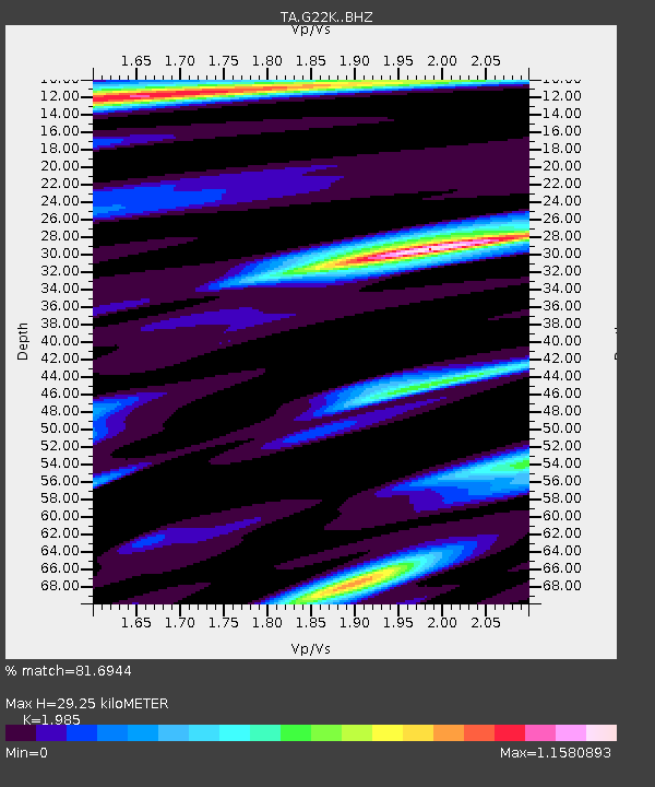
| Estimated Moho Depth: |
29.25 km |
| Estimated Crust Vp/Vs: |
1.99 |
| Assumed Crust Vp: |
6.577 km/s |
| Estimated Crust Vs: |
3.313 km/s |
| Estimated Crust Poisson's Ratio: |
0.33 |
|
| Radial Match: |
81.6944 % |
| Radial Bump: |
400 |
| Transverse Match: |
76.84864 % |
| Transverse Bump: |
400 |
| SOD ConfigId: |
19053131 |
| Insert Time: |
2019-09-03 13:10:11.118 +0000 |
| GWidth: |
2.5 |
| Max Bumps: |
400 |
| Tol: |
0.001 |
|
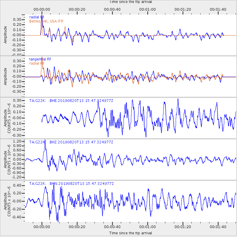
Signal To Noise
| Channel | StoN | STA | LTA |
| TA:G22K: :BHZ:20190820T13:15:47.324977Z | 8.679141 | 5.2811856E-7 | 6.0849175E-8 |
| TA:G22K: :BHN:20190820T13:15:47.324977Z | 3.7931917 | 2.1670981E-7 | 5.7131256E-8 |
| TA:G22K: :BHE:20190820T13:15:47.324977Z | 2.3398736 | 1.2937862E-7 | 5.5292993E-8 |
| Arrivals |
| Ps | 4.5 SECOND |
| PpPs | 13 SECOND |
| PsPs/PpSs | 17 SECOND |


