You are here: Home > Network List > TA - USArray Transportable Network (new EarthScope stations) Stations List
> Station H27K Steamboat Mountain, AK, USA > Earthquake Result Viewer
H27K Steamboat Mountain, AK, USA - Earthquake Result Viewer
| Earthquake location: |
Santa Cruz Islands |
| Earthquake latitude/longitude: |
-11.4/166.3 |
| Earthquake time(UTC): |
2019/08/20 (232) 13:03:52 GMT |
| Earthquake Depth: |
37 km |
| Earthquake Magnitude: |
6.0 Mww |
| Earthquake Catalog/Contributor: |
NEIC PDE/us |
|
| Network: |
TA USArray Transportable Network (new EarthScope stations) |
| Station: |
H27K Steamboat Mountain, AK, USA |
| Lat/Lon: |
66.23 N/141.53 W |
| Elevation: |
786 m |
|
| Distance: |
86.3 deg |
| Az: |
18.714 deg |
| Baz: |
230.92 deg |
| Ray Param: |
0.04411693 |
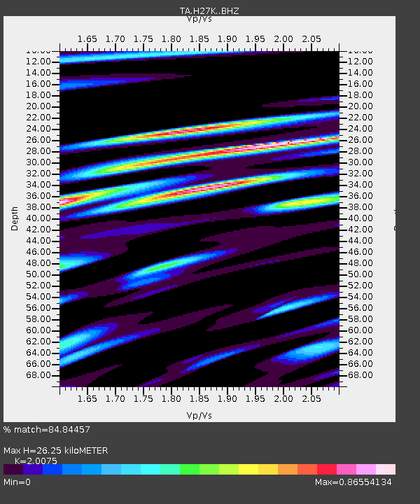
| Estimated Moho Depth: |
26.25 km |
| Estimated Crust Vp/Vs: |
2.01 |
| Assumed Crust Vp: |
6.577 km/s |
| Estimated Crust Vs: |
3.276 km/s |
| Estimated Crust Poisson's Ratio: |
0.33 |
|
| Radial Match: |
84.84457 % |
| Radial Bump: |
400 |
| Transverse Match: |
69.00348 % |
| Transverse Bump: |
400 |
| SOD ConfigId: |
19053131 |
| Insert Time: |
2019-09-03 13:10:20.690 +0000 |
| GWidth: |
2.5 |
| Max Bumps: |
400 |
| Tol: |
0.001 |
|

Signal To Noise
| Channel | StoN | STA | LTA |
| TA:H27K: :BHZ:20190820T13:15:59.300013Z | 7.3770604 | 4.067616E-7 | 5.5138706E-8 |
| TA:H27K: :BHN:20190820T13:15:59.300013Z | 2.5922046 | 1.6925308E-7 | 6.52931E-8 |
| TA:H27K: :BHE:20190820T13:15:59.300013Z | 2.4912508 | 1.6743154E-7 | 6.720782E-8 |
| Arrivals |
| Ps | 4.1 SECOND |
| PpPs | 12 SECOND |
| PsPs/PpSs | 16 SECOND |


