You are here: Home > Network List > TA - USArray Transportable Network (new EarthScope stations) Stations List
> Station I26K Coal Creek Mining Camp, AK, USA > Earthquake Result Viewer
I26K Coal Creek Mining Camp, AK, USA - Earthquake Result Viewer
| Earthquake location: |
Santa Cruz Islands |
| Earthquake latitude/longitude: |
-11.4/166.3 |
| Earthquake time(UTC): |
2019/08/20 (232) 13:03:52 GMT |
| Earthquake Depth: |
37 km |
| Earthquake Magnitude: |
6.0 Mww |
| Earthquake Catalog/Contributor: |
NEIC PDE/us |
|
| Network: |
TA USArray Transportable Network (new EarthScope stations) |
| Station: |
I26K Coal Creek Mining Camp, AK, USA |
| Lat/Lon: |
65.31 N/143.15 W |
| Elevation: |
338 m |
|
| Distance: |
85.2 deg |
| Az: |
18.997 deg |
| Baz: |
229.458 deg |
| Ray Param: |
0.044908237 |
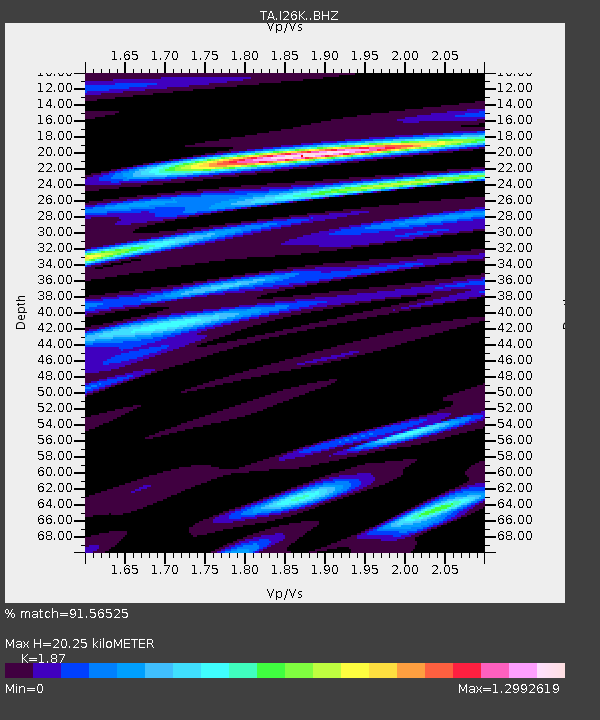
| Estimated Moho Depth: |
20.25 km |
| Estimated Crust Vp/Vs: |
1.87 |
| Assumed Crust Vp: |
6.566 km/s |
| Estimated Crust Vs: |
3.511 km/s |
| Estimated Crust Poisson's Ratio: |
0.30 |
|
| Radial Match: |
91.56525 % |
| Radial Bump: |
400 |
| Transverse Match: |
87.0649 % |
| Transverse Bump: |
400 |
| SOD ConfigId: |
19053131 |
| Insert Time: |
2019-09-03 13:10:24.658 +0000 |
| GWidth: |
2.5 |
| Max Bumps: |
400 |
| Tol: |
0.001 |
|

Signal To Noise
| Channel | StoN | STA | LTA |
| TA:I26K: :BHZ:20190820T13:15:53.824977Z | 13.433021 | 6.606294E-7 | 4.917951E-8 |
| TA:I26K: :BHN:20190820T13:15:53.824977Z | 5.0784707 | 2.1213798E-7 | 4.1772022E-8 |
| TA:I26K: :BHE:20190820T13:15:53.824977Z | 3.9828644 | 2.1018288E-7 | 5.277179E-8 |
| Arrivals |
| Ps | 2.7 SECOND |
| PpPs | 8.6 SECOND |
| PsPs/PpSs | 11 SECOND |


