You are here: Home > Network List > TA - USArray Transportable Network (new EarthScope stations) Stations List
> Station L19K White Mountain, AK, USA > Earthquake Result Viewer
L19K White Mountain, AK, USA - Earthquake Result Viewer
| Earthquake location: |
Santa Cruz Islands |
| Earthquake latitude/longitude: |
-11.4/166.3 |
| Earthquake time(UTC): |
2019/08/20 (232) 13:03:52 GMT |
| Earthquake Depth: |
37 km |
| Earthquake Magnitude: |
6.0 Mww |
| Earthquake Catalog/Contributor: |
NEIC PDE/us |
|
| Network: |
TA USArray Transportable Network (new EarthScope stations) |
| Station: |
L19K White Mountain, AK, USA |
| Lat/Lon: |
62.18 N/154.85 W |
| Elevation: |
650 m |
|
| Distance: |
79.3 deg |
| Az: |
17.425 deg |
| Baz: |
218.755 deg |
| Ray Param: |
0.048996896 |
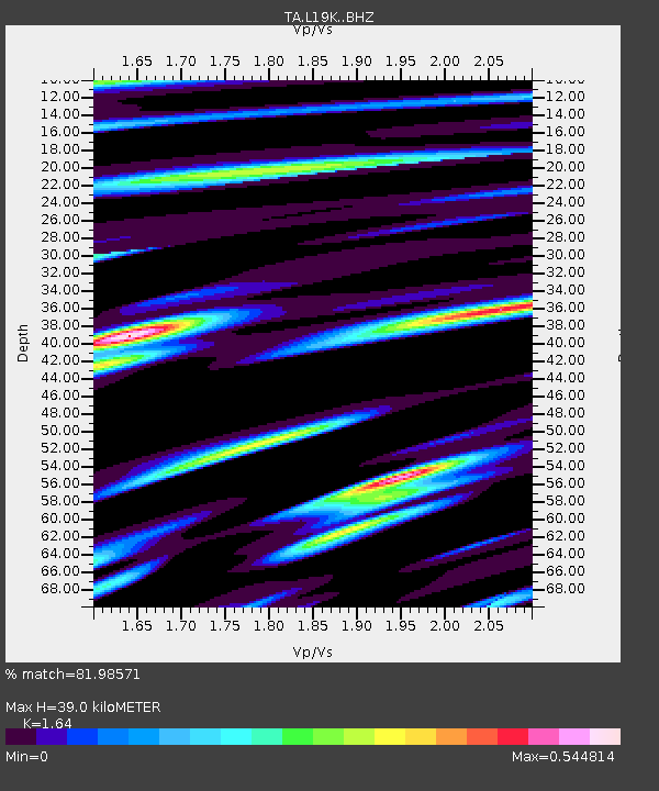
| Estimated Moho Depth: |
39.0 km |
| Estimated Crust Vp/Vs: |
1.64 |
| Assumed Crust Vp: |
6.438 km/s |
| Estimated Crust Vs: |
3.926 km/s |
| Estimated Crust Poisson's Ratio: |
0.20 |
|
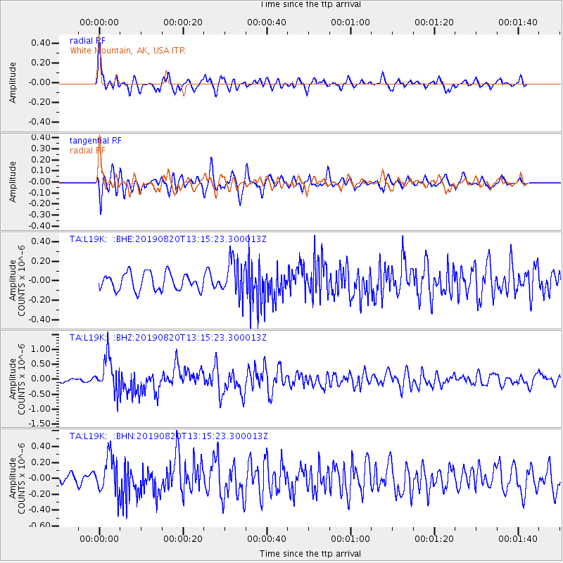
| Radial Match: |
81.98571 % |
| Radial Bump: |
400 |
| Transverse Match: |
79.69565 % |
| Transverse Bump: |
400 |
| SOD ConfigId: |
19053131 |
| Insert Time: |
2019-09-03 13:10:39.208 +0000 |
| GWidth: |
2.5 |
| Max Bumps: |
400 |
| Tol: |
0.001 |
|
Signal To Noise
| Channel | StoN | STA | LTA |
| TA:L19K: :BHZ:20190820T13:15:23.300013Z | 11.301406 | 5.793559E-7 | 5.1264056E-8 |
| TA:L19K: :BHN:20190820T13:15:23.300013Z | 3.5858119 | 2.3417617E-7 | 6.530632E-8 |
| TA:L19K: :BHE:20190820T13:15:23.300013Z | 2.0884666 | 1.8026287E-7 | 8.6313506E-8 |
| Arrivals |
| Ps | 4.0 SECOND |
| PpPs | 15 SECOND |
| PsPs/PpSs | 19 SECOND |


