You are here: Home > Network List > TA - USArray Transportable Network (new EarthScope stations) Stations List
> Station M19K Big River Lodge, Big River, AK, USA > Earthquake Result Viewer
M19K Big River Lodge, Big River, AK, USA - Earthquake Result Viewer
| Earthquake location: |
Santa Cruz Islands |
| Earthquake latitude/longitude: |
-11.4/166.3 |
| Earthquake time(UTC): |
2019/08/20 (232) 13:03:52 GMT |
| Earthquake Depth: |
37 km |
| Earthquake Magnitude: |
6.0 Mww |
| Earthquake Catalog/Contributor: |
NEIC PDE/us |
|
| Network: |
TA USArray Transportable Network (new EarthScope stations) |
| Station: |
M19K Big River Lodge, Big River, AK, USA |
| Lat/Lon: |
61.90 N/154.39 W |
| Elevation: |
521 m |
|
| Distance: |
79.2 deg |
| Az: |
17.776 deg |
| Baz: |
219.229 deg |
| Ray Param: |
0.04905137 |
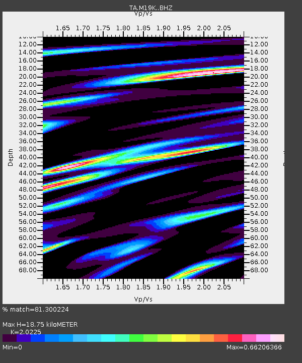
| Estimated Moho Depth: |
18.75 km |
| Estimated Crust Vp/Vs: |
2.02 |
| Assumed Crust Vp: |
6.566 km/s |
| Estimated Crust Vs: |
3.247 km/s |
| Estimated Crust Poisson's Ratio: |
0.34 |
|
| Radial Match: |
81.300224 % |
| Radial Bump: |
400 |
| Transverse Match: |
76.86339 % |
| Transverse Bump: |
400 |
| SOD ConfigId: |
19053131 |
| Insert Time: |
2019-09-03 13:10:44.578 +0000 |
| GWidth: |
2.5 |
| Max Bumps: |
400 |
| Tol: |
0.001 |
|

Signal To Noise
| Channel | StoN | STA | LTA |
| TA:M19K: :BHZ:20190820T13:15:22.875025Z | 7.171746 | 6.1445627E-7 | 8.567737E-8 |
| TA:M19K: :BHN:20190820T13:15:22.875025Z | 3.2055192 | 1.9690259E-7 | 6.1426114E-8 |
| TA:M19K: :BHE:20190820T13:15:22.875025Z | 3.123748 | 1.4428787E-7 | 4.619062E-8 |
| Arrivals |
| Ps | 3.0 SECOND |
| PpPs | 8.4 SECOND |
| PsPs/PpSs | 11 SECOND |


