You are here: Home > Network List > TA - USArray Transportable Network (new EarthScope stations) Stations List
> Station O17K Koliganek, Bristol Bay, AK, USA > Earthquake Result Viewer
O17K Koliganek, Bristol Bay, AK, USA - Earthquake Result Viewer
| Earthquake location: |
Santa Cruz Islands |
| Earthquake latitude/longitude: |
-11.4/166.3 |
| Earthquake time(UTC): |
2019/08/20 (232) 13:03:52 GMT |
| Earthquake Depth: |
37 km |
| Earthquake Magnitude: |
6.0 Mww |
| Earthquake Catalog/Contributor: |
NEIC PDE/us |
|
| Network: |
TA USArray Transportable Network (new EarthScope stations) |
| Station: |
O17K Koliganek, Bristol Bay, AK, USA |
| Lat/Lon: |
59.77 N/157.09 W |
| Elevation: |
156 m |
|
| Distance: |
76.7 deg |
| Az: |
18.058 deg |
| Baz: |
216.93 deg |
| Ray Param: |
0.05074432 |
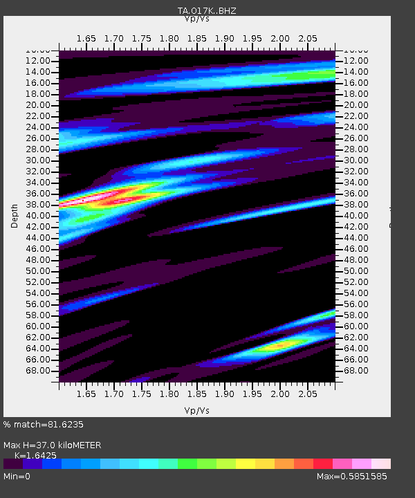
| Estimated Moho Depth: |
37.0 km |
| Estimated Crust Vp/Vs: |
1.64 |
| Assumed Crust Vp: |
6.276 km/s |
| Estimated Crust Vs: |
3.821 km/s |
| Estimated Crust Poisson's Ratio: |
0.21 |
|
| Radial Match: |
81.6235 % |
| Radial Bump: |
361 |
| Transverse Match: |
65.47055 % |
| Transverse Bump: |
400 |
| SOD ConfigId: |
19053131 |
| Insert Time: |
2019-09-03 13:10:57.494 +0000 |
| GWidth: |
2.5 |
| Max Bumps: |
400 |
| Tol: |
0.001 |
|
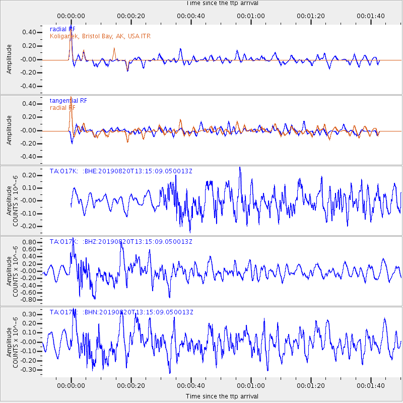
Signal To Noise
| Channel | StoN | STA | LTA |
| TA:O17K: :BHZ:20190820T13:15:09.050013Z | 3.9096026 | 3.7722407E-7 | 9.6486545E-8 |
| TA:O17K: :BHN:20190820T13:15:09.050013Z | 2.7728665 | 1.6192428E-7 | 5.8395983E-8 |
| TA:O17K: :BHE:20190820T13:15:09.050013Z | 1.6949006 | 7.9337426E-8 | 4.6809483E-8 |
| Arrivals |
| Ps | 3.9 SECOND |
| PpPs | 15 SECOND |
| PsPs/PpSs | 19 SECOND |


