You are here: Home > Network List > US - United States National Seismic Network Stations List
> Station HAWA Hanford, Washington, USA > Earthquake Result Viewer
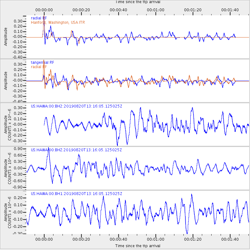
HAWA Hanford, Washington, USA - Earthquake Result Viewer
*The percent match for this event was below the threshold and hence no stack was calculated.
| Earthquake location: |
Santa Cruz Islands |
| Earthquake latitude/longitude: |
-11.4/166.3 |
| Earthquake time(UTC): |
2019/08/20 (232) 13:03:52 GMT |
| Earthquake Depth: |
37 km |
| Earthquake Magnitude: |
6.0 Mww |
| Earthquake Catalog/Contributor: |
NEIC PDE/us |
|
| Network: |
US United States National Seismic Network |
| Station: |
HAWA Hanford, Washington, USA |
| Lat/Lon: |
46.39 N/119.53 W |
| Elevation: |
364 m |
|
| Distance: |
87.5 deg |
| Az: |
41.8 deg |
| Baz: |
250.804 deg |
| Ray Param: |
$rayparam |
*The percent match for this event was below the threshold and hence was not used in the summary stack. |
|
| Radial Match: |
77.766 % |
| Radial Bump: |
399 |
| Transverse Match: |
68.9159 % |
| Transverse Bump: |
393 |
| SOD ConfigId: |
19053131 |
| Insert Time: |
2019-09-03 13:11:44.123 +0000 |
| GWidth: |
2.5 |
| Max Bumps: |
400 |
| Tol: |
0.001 |
|
Signal To Noise
| Channel | StoN | STA | LTA |
| US:HAWA:00:BHZ:20190820T13:16:05.125025Z | 5.4903393 | 4.5383464E-7 | 8.2660584E-8 |
| US:HAWA:00:BH1:20190820T13:16:05.125025Z | 0.7774992 | 6.064593E-8 | 7.800128E-8 |
| US:HAWA:00:BH2:20190820T13:16:05.125025Z | 1.1610588 | 8.63414E-8 | 7.436437E-8 |
| Arrivals |
| Ps | |
| PpPs | |
| PsPs/PpSs | |


