You are here: Home > Network List > US - United States National Seismic Network Stations List
> Station MSO Missoula, Montana, USA > Earthquake Result Viewer
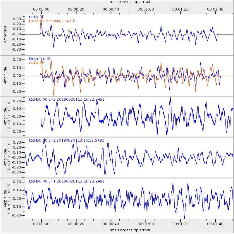
MSO Missoula, Montana, USA - Earthquake Result Viewer
*The percent match for this event was below the threshold and hence no stack was calculated.
| Earthquake location: |
Santa Cruz Islands |
| Earthquake latitude/longitude: |
-11.4/166.3 |
| Earthquake time(UTC): |
2019/08/20 (232) 13:03:52 GMT |
| Earthquake Depth: |
37 km |
| Earthquake Magnitude: |
6.0 Mww |
| Earthquake Catalog/Contributor: |
NEIC PDE/us |
|
| Network: |
US United States National Seismic Network |
| Station: |
MSO Missoula, Montana, USA |
| Lat/Lon: |
46.83 N/113.94 W |
| Elevation: |
1264 m |
|
| Distance: |
91.3 deg |
| Az: |
42.52 deg |
| Baz: |
254.864 deg |
| Ray Param: |
$rayparam |
*The percent match for this event was below the threshold and hence was not used in the summary stack. |
|
| Radial Match: |
54.858482 % |
| Radial Bump: |
400 |
| Transverse Match: |
45.958736 % |
| Transverse Bump: |
400 |
| SOD ConfigId: |
19053131 |
| Insert Time: |
2019-09-03 13:11:47.348 +0000 |
| GWidth: |
2.5 |
| Max Bumps: |
400 |
| Tol: |
0.001 |
|
Signal To Noise
| Channel | StoN | STA | LTA |
| US:MSO:00:BHZ:20190820T13:16:22.949Z | 3.01688 | 1.8795002E-7 | 6.229947E-8 |
| US:MSO:00:BH1:20190820T13:16:22.949Z | 1.1111537 | 7.778446E-8 | 7.000333E-8 |
| US:MSO:00:BH2:20190820T13:16:22.949Z | 0.92824405 | 9.190662E-8 | 9.901127E-8 |
| Arrivals |
| Ps | |
| PpPs | |
| PsPs/PpSs | |


