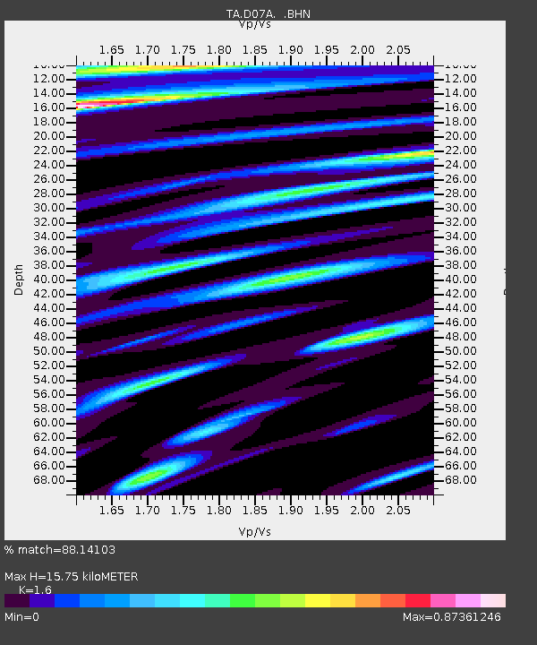
D07A Quincy, WA, USA - Earthquake Result Viewer
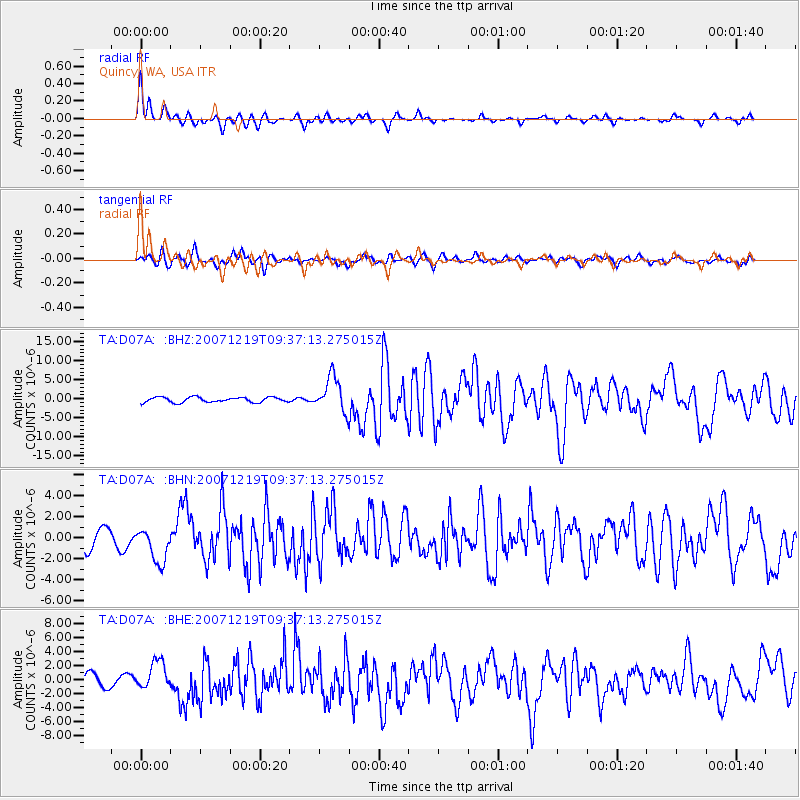
Earthquake location: Andreanof Islands, Aleutian Is.
Earthquake latitude/longitude: 51.4/-179.5
Earthquake time(UTC): 2007/12/19 (353) 09:30:27 GMT
Earthquake Depth: 29 km
Earthquake Magnitude: 6.4 MB, 7.1 MS, 7.1 MW, 7.0 MW
Earthquake Catalog/Contributor: WHDF/NEIC
Network: TA USArray Transportable Network (new EarthScope stations)
Station: D07A Quincy, WA, USA
Lat/Lon: 47.19 N/119.97 W
Elevation: 453 m
Distance: 38.1 deg
Az: 72.155 deg
Baz: 298.946 deg
Ray Param: 0.075679235
Estimated Moho Depth: 15.75 km
Estimated Crust Vp/Vs: 1.60
Assumed Crust Vp: 6.419 km/s
Estimated Crust Vs: 4.012 km/s
Estimated Crust Poisson's Ratio: 0.18
Radial Match: 88.14103 %
Radial Bump: 400
Transverse Match: 75.56145 %
Transverse Bump: 400
SOD ConfigId: 2564
Insert Time: 2010-03-07 03:25:06.509 +0000
GWidth: 2.5
Max Bumps: 400
Tol: 0.001

Signal To Noise

ChannelStoNSTALTA
TA:D07A: :BHN:20071219T09:37:13.275015Z1.81144311.6368028E-69.0359055E-7
TA:D07A: :BHE:20071219T09:37:13.275015Z2.81475282.009042E-67.137544E-7
TA:D07A: :BHZ:20071219T09:37:13.275015Z6.9003094.5972674E-66.662408E-7
Arrivals
Ps1.6 SECOND
PpPs5.9 SECOND
PsPs/PpSs7.5 SECOND