You are here: Home > Network List > TA - USArray Transportable Network (new EarthScope stations) Stations List
> Station D07A Quincy, WA, USA > Earthquake Result Viewer
D07A Quincy, WA, USA - Earthquake Result Viewer
| Earthquake location: |
Peru-Ecuador Border Region |
| Earthquake latitude/longitude: |
-2.3/-77.8 |
| Earthquake time(UTC): |
2007/11/16 (320) 03:13:00 GMT |
| Earthquake Depth: |
123 km |
| Earthquake Magnitude: |
6.3 MB, 6.8 MW, 6.7 MW |
| Earthquake Catalog/Contributor: |
WHDF/NEIC |
|
| Network: |
TA USArray Transportable Network (new EarthScope stations) |
| Station: |
D07A Quincy, WA, USA |
| Lat/Lon: |
47.19 N/119.97 W |
| Elevation: |
453 m |
|
| Distance: |
61.6 deg |
| Az: |
328.651 deg |
| Baz: |
130.338 deg |
| Ray Param: |
0.06043728 |
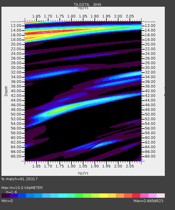
| Estimated Moho Depth: |
10.0 km |
| Estimated Crust Vp/Vs: |
1.60 |
| Assumed Crust Vp: |
6.419 km/s |
| Estimated Crust Vs: |
4.012 km/s |
| Estimated Crust Poisson's Ratio: |
0.18 |
|
| Radial Match: |
91.28317 % |
| Radial Bump: |
400 |
| Transverse Match: |
84.711395 % |
| Transverse Bump: |
400 |
| SOD ConfigId: |
2564 |
| Insert Time: |
2010-03-07 03:25:12.483 +0000 |
| GWidth: |
2.5 |
| Max Bumps: |
400 |
| Tol: |
0.001 |
|
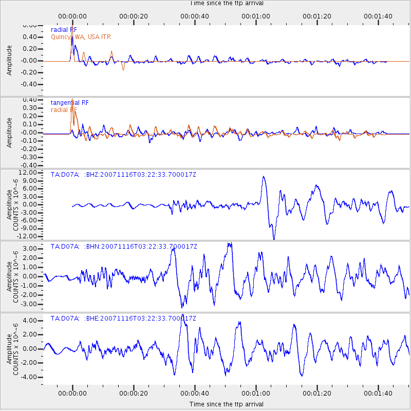
Signal To Noise
| Channel | StoN | STA | LTA |
| TA:D07A: :BHN:20071116T03:22:33.700017Z | 0.79399174 | 3.5155674E-7 | 4.427713E-7 |
| TA:D07A: :BHE:20071116T03:22:33.700017Z | 0.691069 | 5.449018E-7 | 7.884912E-7 |
| TA:D07A: :BHZ:20071116T03:22:33.700017Z | 2.1564305 | 1.0329838E-6 | 4.790249E-7 |
| Arrivals |
| Ps | 1.0 SECOND |
| PpPs | 3.9 SECOND |
| PsPs/PpSs | 4.8 SECOND |


