You are here: Home > Network List > TA - USArray Transportable Network (new EarthScope stations) Stations List
> Station D07A Quincy, WA, USA > Earthquake Result Viewer
D07A Quincy, WA, USA - Earthquake Result Viewer
| Earthquake location: |
Santa Cruz Islands |
| Earthquake latitude/longitude: |
-11.6/165.8 |
| Earthquake time(UTC): |
2007/09/02 (245) 01:05:18 GMT |
| Earthquake Depth: |
35 km |
| Earthquake Magnitude: |
5.9 MB, 7.3 MS, 7.2 MW, 6.9 ME |
| Earthquake Catalog/Contributor: |
WHDF/NEIC |
|
| Network: |
TA USArray Transportable Network (new EarthScope stations) |
| Station: |
D07A Quincy, WA, USA |
| Lat/Lon: |
47.19 N/119.97 W |
| Elevation: |
453 m |
|
| Distance: |
88.0 deg |
| Az: |
41.058 deg |
| Baz: |
250.676 deg |
| Ray Param: |
0.04286856 |
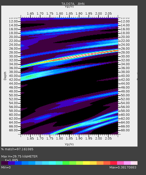
| Estimated Moho Depth: |
29.75 km |
| Estimated Crust Vp/Vs: |
1.88 |
| Assumed Crust Vp: |
6.419 km/s |
| Estimated Crust Vs: |
3.405 km/s |
| Estimated Crust Poisson's Ratio: |
0.30 |
|
| Radial Match: |
97.161865 % |
| Radial Bump: |
278 |
| Transverse Match: |
93.08685 % |
| Transverse Bump: |
400 |
| SOD ConfigId: |
2564 |
| Insert Time: |
2010-03-07 03:25:24.579 +0000 |
| GWidth: |
2.5 |
| Max Bumps: |
400 |
| Tol: |
0.001 |
|
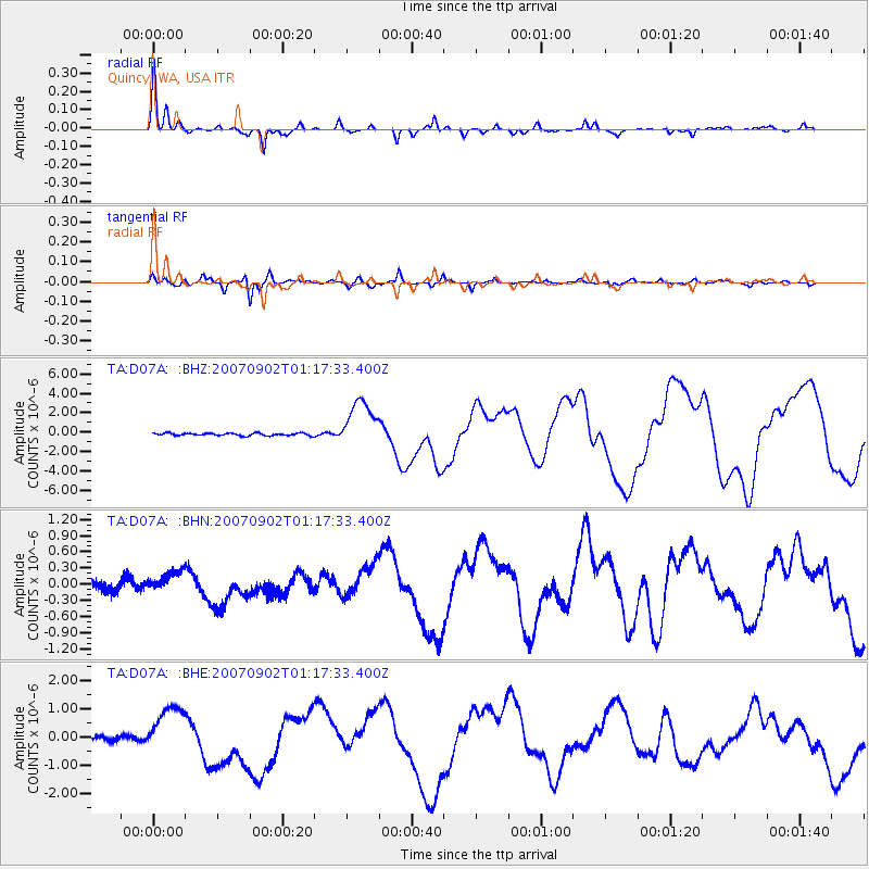
Signal To Noise
| Channel | StoN | STA | LTA |
| TA:D07A: :BHN:20070902T01:17:33.400Z | 2.3374765 | 2.0241787E-7 | 8.659675E-8 |
| TA:D07A: :BHE:20070902T01:17:33.400Z | 8.874803 | 8.8397695E-7 | 9.960526E-8 |
| TA:D07A: :BHZ:20070902T01:17:33.400Z | 19.700184 | 2.4878614E-6 | 1.262862E-7 |
| Arrivals |
| Ps | 4.2 SECOND |
| PpPs | 13 SECOND |
| PsPs/PpSs | 17 SECOND |


