You are here: Home > Network List > TA - USArray Transportable Network (new EarthScope stations) Stations List
> Station D07A Quincy, WA, USA > Earthquake Result Viewer
D07A Quincy, WA, USA - Earthquake Result Viewer
| Earthquake location: |
Near Coast Of Peru |
| Earthquake latitude/longitude: |
-13.6/-76.6 |
| Earthquake time(UTC): |
2007/08/17 (229) 13:18:13 GMT |
| Earthquake Depth: |
48 km |
| Earthquake Magnitude: |
5.6 MB, 5.6 MS, 5.9 MW |
| Earthquake Catalog/Contributor: |
WHDF/NEIC |
|
| Network: |
TA USArray Transportable Network (new EarthScope stations) |
| Station: |
D07A Quincy, WA, USA |
| Lat/Lon: |
47.19 N/119.97 W |
| Elevation: |
453 m |
|
| Distance: |
71.9 deg |
| Az: |
330.476 deg |
| Baz: |
135.366 deg |
| Ray Param: |
0.05394068 |
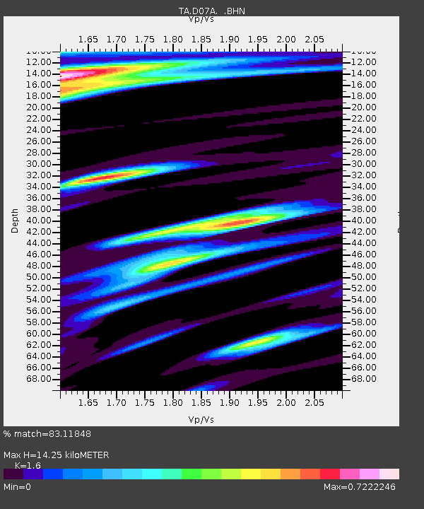
| Estimated Moho Depth: |
14.25 km |
| Estimated Crust Vp/Vs: |
1.60 |
| Assumed Crust Vp: |
6.419 km/s |
| Estimated Crust Vs: |
4.012 km/s |
| Estimated Crust Poisson's Ratio: |
0.18 |
|
| Radial Match: |
83.11848 % |
| Radial Bump: |
400 |
| Transverse Match: |
70.93059 % |
| Transverse Bump: |
400 |
| SOD ConfigId: |
2564 |
| Insert Time: |
2010-03-07 03:25:26.802 +0000 |
| GWidth: |
2.5 |
| Max Bumps: |
400 |
| Tol: |
0.001 |
|
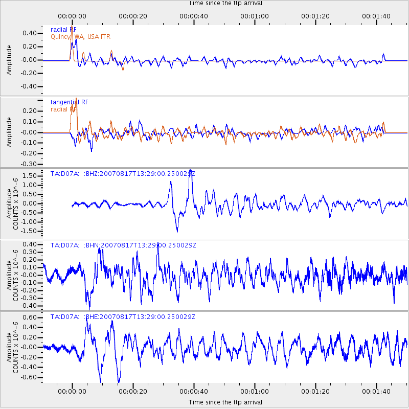
Signal To Noise
| Channel | StoN | STA | LTA |
| TA:D07A: :BHN:20070817T13:29:00.250029Z | 1.5927709 | 1.2587176E-7 | 7.902691E-8 |
| TA:D07A: :BHE:20070817T13:29:00.250029Z | 3.3026106 | 1.9770444E-7 | 5.9863076E-8 |
| TA:D07A: :BHZ:20070817T13:29:00.250029Z | 8.518357 | 6.8084233E-7 | 7.992649E-8 |
| Arrivals |
| Ps | 1.4 SECOND |
| PpPs | 5.6 SECOND |
| PsPs/PpSs | 6.9 SECOND |


