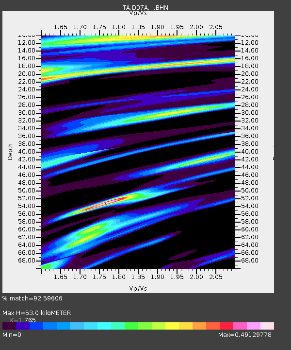
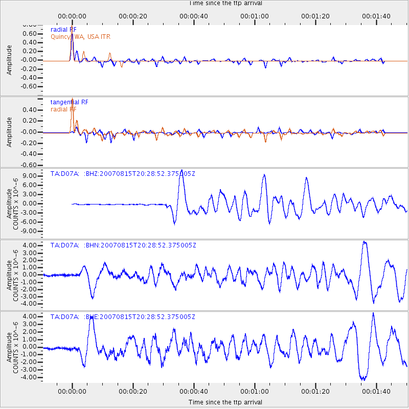
D07A Quincy, WA, USA - Earthquake Result Viewer

Earthquake location: Andreanof Islands, Aleutian Is.
Earthquake latitude/longitude: 50.3/-177.5
Earthquake time(UTC): 2007/08/15 (227) 20:22:11 GMT
Earthquake Depth: 9.0 km
Earthquake Magnitude: 6.3 MB, 6.2 MS, 6.4 MW, 5.9 ML
Earthquake Catalog/Contributor: WHDF/NEIC
Network: TA USArray Transportable Network (new EarthScope stations)
Station: D07A Quincy, WA, USA
Lat/Lon: 47.19 N/119.97 W
Elevation: 453 m
Distance: 37.3 deg
Az: 71.9 deg
Baz: 296.694 deg
Ray Param: 0.07622793
Estimated Moho Depth: 53.0 km
Estimated Crust Vp/Vs: 1.76
Assumed Crust Vp: 6.419 km/s
Estimated Crust Vs: 3.637 km/s
Estimated Crust Poisson's Ratio: 0.26
Radial Match: 92.59606 %
Radial Bump: 400
Transverse Match: 83.0586 %
Transverse Bump: 275
SOD ConfigId: 2564
Insert Time: 2010-03-07 03:25:32.632 +0000
GWidth: 2.5
Max Bumps: 400
Tol: 0.001

Signal To Noise

ChannelStoNSTALTA
TA:D07A: :BHN:20070815T20:28:52.375005Z6.6844196.238129E-79.332343E-8
TA:D07A: :BHE:20070815T20:28:52.375005Z14.0792331.0651825E-67.565628E-8
TA:D07A: :BHZ:20070815T20:28:52.375005Z26.9521062.5619165E-69.505441E-8
Arrivals
Ps6.8 SECOND
PpPs21 SECOND
PsPs/PpSs28 SECOND