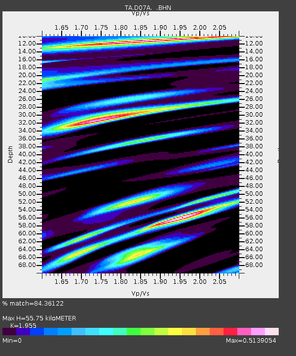
D07A Quincy, WA, USA - Earthquake Result Viewer
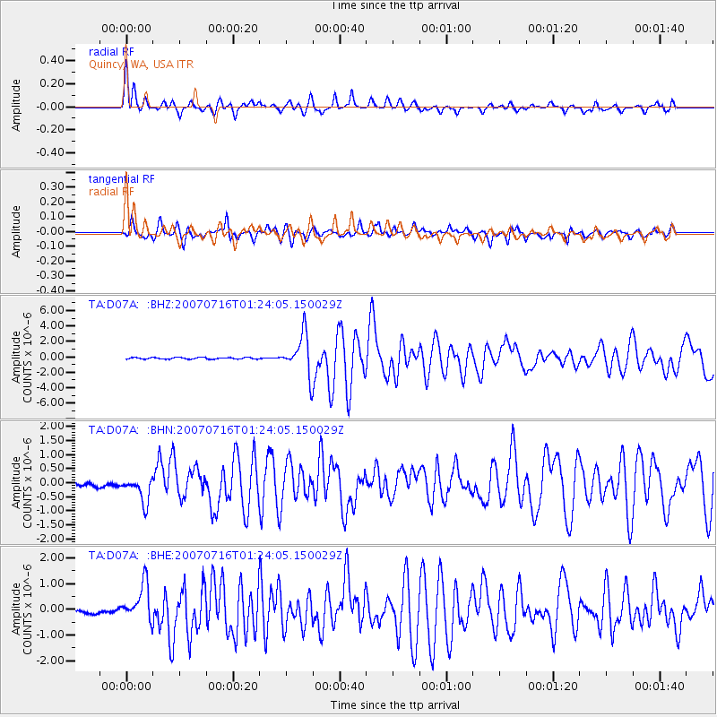
Earthquake location: Near West Coast Of Honshu, Japan
Earthquake latitude/longitude: 37.5/138.4
Earthquake time(UTC): 2007/07/16 (197) 01:13:22 GMT
Earthquake Depth: 12 km
Earthquake Magnitude: 6.5 MB, 6.4 MS, 6.6 MW, 6.5 MW
Earthquake Catalog/Contributor: WHDF/NEIC
Network: TA USArray Transportable Network (new EarthScope stations)
Station: D07A Quincy, WA, USA
Lat/Lon: 47.19 N/119.97 W
Elevation: 453 m
Distance: 70.4 deg
Az: 45.156 deg
Baz: 304.26 deg
Ray Param: 0.0549807
Estimated Moho Depth: 55.75 km
Estimated Crust Vp/Vs: 1.96
Assumed Crust Vp: 6.419 km/s
Estimated Crust Vs: 3.283 km/s
Estimated Crust Poisson's Ratio: 0.32
Radial Match: 84.36122 %
Radial Bump: 400
Transverse Match: 86.29088 %
Transverse Bump: 400
SOD ConfigId: 2564
Insert Time: 2010-03-07 03:25:37.607 +0000
GWidth: 2.5
Max Bumps: 400
Tol: 0.001

Signal To Noise

ChannelStoNSTALTA
TA:D07A: :BHN:20070716T01:24:05.150029Z5.4654884.8168175E-78.813152E-8
TA:D07A: :BHE:20070716T01:24:05.150029Z5.27286967.1538466E-71.3567274E-7
TA:D07A: :BHZ:20070716T01:24:05.150029Z25.1233352.6281941E-61.0461167E-7
Arrivals
Ps8.6 SECOND
PpPs25 SECOND
PsPs/PpSs33 SECOND